Saturday, December 26, 2009

ABC Arizona Communities

Chandler: “A Modern Eden,” “The Five Star City,” and a “High Tech Oasis in the Silicon Desert.”

In addition to mineral riches, Arizona has produced great wealth through land development and agriculture. Inspired by the ancient tradition of an Eden-like oasis in the forbidding desert, Arizona developers have created a number of planned communities over the years, each with its unique center-piece drawing shoppers to landscaped arcades and homebuyers to pleasant abodes set in a fabulous dreamscape.

Dr. A. J. Chandler (1859-1950), a Canadian veterinarian recruited to head Arizona’s first Livestock Sanitary Board in 1887, was one of those developers. And his Chandler Ranch, subdivided in 1911, became one of those dreamscapes. The real estate office opened in the barren desert south of Tempe May 17, 1912 and sold $50,000 worth of parcels that first day.

Chandler Ranch begins selling residential and commercial lots and small farmsteads.

The one square mile townsite centered around a landscaped park just below the intersection of Arizona Avenue and Chandler Blvd. (Cleveland street at the time). And within a year a world class desert winter resort in the popular Mission Revival style opened on the west side of the park. Called the San Marcos, it was the first cast-in-place reinforced concrete structure in Arizona. The remaining sides of the town square were fronted by business blocks tied together by a continuous colonnade that shaded sidewalks.

Designed by California architect Arthur Burnett Benton, the San Marcos offered guests a number of detached bungalows west of the main hotel set in a paradise of fountains, pools, flower beds, palm-lined walks and fragrant citrus trees. This view of bungalows is from a penny postcard colorized by the Albertype process about 1915. Remodeled in 1954 and then restored in 1986, the Crowne Plaza San Marcos Golf Resort remains the centerpiece of the historic district.

By 1914 there were 40 businesses serving a population of at least 1,000. The Basha family opened its first store close by in 1920. But agriculture was the foundation of the economy in those days. With irrigation, farmers grew fruit, vegetables and alfalfa. An Ostrich farm, providing feathers for ladies hats, boomed until styles changed in the 1920s. The Goodyear Tire and Rubber Company leased land a few miles south to grow the new variety of Egyptian long staple cotton used in auto and truck tire cords and fabric covering of airplanes. There was a small community named Goodyear located at the present day intersection of Alma School and Ocotillo Roads. The community was renamed Ocotillo just before World War Two when the rubber company created a new Goodyear to serve a naval air field at Litchfield Park.

Dr. Chandler was an expert on animal nutrition for the Ferry seed company before coming to Arizona. He noticed that the desert in the Salt River Valley bloomed upon the application of water. For his real estate development he organized the Consolidated Canal Company and supported the effort to build Roosevelt Dam as a year-round source of water.

The Chandler Heights Citrus District was established in 1928 fifteen miles southeast. But it was the buildup for war that brought a growth spurt to Chandler. The US Army Air Corps opened Higley Field 10 miles east of Chandler in 1941 to train pilots, renaming it Williams Field the following year. By 1950 the population of Chandler had more than doubled to 3,800, still a small oasis surrounded by irrigated fields and desert.

Here’s a bird’s-eye-view of A. J. Chandler park looking southwest in about 1955, published as a postcard by Petley Studios. At right is the front of the San Marcos, with a colonnade front business block in center. After Arizona Avenue became Highway 87 to Tucson, in 1940 the town square was divided in two by a new four-lane highway.

Beginning after the war, the Salt River Valley attracted manufacturing plants, a workforce looking for a comfortable southern California inspired suburban lifestyle and retirees seeking relief from cold Midwestern winters. More recently, aggressive real estate marketing populated Valley cities like Chandler with upwardly mobile dreamers settling under the palms often on the shoreline of a sparkling man-made lake. Chandler gobbled up most of the farms and the desert, passing a population of 100,000 in the 1990s and then 200,000 early in this decade to become the fifth largest city in Arizona.

A 2008 entrance design by Lamb Architects for a $3.7 million office condo located at Chandler Blvd. and Kyrene Road in Chandler.

Monday, December 21, 2009

The Arizona Gold Rush

[click on an image to view full size; right-click to save; use back button to return to blog]

"There’s gold in them thar hills"

In Arizona, copper has proven a more valuable metal than gold. And much of the gold produced since 1900 has been recovered from copper sulfide ores as a byproduct of the copper concentration and smelting process. Spanish conquistadors came to Arizona searching for gold and found silver instead. Mexican prospectors began mining the gold missed by their former Spanish rulers. But it was silver mining in the mountains south of Tucson that lured the first Americans to Arizona. Soon, they too discovered the more valuable yellow metal. And a gold rush along the lower Colorado and Gila rivers initiated settlement in the western part of New Mexico Territory, an area that would soon become the Territory of Arizona.

“By 1858 prospectors had located placer beds on the Gila River. There they started Arizona’s first modern gold rush, which resulted in the establishment of Gila City. In a few years perhaps 1500 people were living there on the banks of the Gila, panning gold and defying the heat and perils of an unknown desert. In a land of almost perpetual drouth, their city was finally swept away by an unexpected flood, and the first gold rush was over.”
- - p.227, Frank Cullen Brophy, Arizona Sketch Book (1952)

Gila City was established at the end of 1858 and had a population of 400 by the spring of 1859. The placer deposits apparently played out shortly afterward and the flood came in 1862. By then, prospectors had already hit pay dirt along the Colorado River, at El Dorado Canyon in April 1861 and at La Paz lagoon in 1862.

This map by Norton Allen appeared in the April 1953 issue of Desert magazine. Gila City was located on the river about 12 miles east of the McPhaul placer (16). The town of La Paz was located close to the upper placer (14), while Ehrenburg was near the lower La Paz placer. This map also omits a good placer stream southwest of Payson.
[click on an image to view full size; right-click to save; use back button to return to blog]

“More than 5,000 people worked the placers of La Paz and moved the freight and supplies which came by boat up the Colorado River from distant San Francisco.” (Brophy, p. 228) The bustling town of 155 adobe houses and numerous saloons and stores, missed becoming the capital of the new Territory of Arizona in 1864 by a single vote in the legislature. More than one Arizona family of merchants got their start in the gold camps of La Paz and Ehrenburg.

Throughout the history of Arizona Territory, San Francisco was the principle source of information, goods, machinery and financing. The gold rush city by the bay was the largest city in the West and an important financial, publishing and higher education center. San Francisco sent miners to the new gold rush in Arizona and by 1877 sent the first railroad line to Yuma.

Gold has been mined throughout the central mountains and low lying deserts of the state. While the soils and clays of the Colorado Plateau region commonly hold very fine particles of gold, extraction has proven unprofitable. Instead, gold is sought in underground veins of quartz and sulphide deposits or the surface sand and gravel of placer deposits.

A model of an Arizona gold mine displayed at the Chicago Field Museum of Natural History in 1922 showed how underground mining of pyrites or chalcopyrite sulphides enclosed in quartz could produce as much as $40 in gold per ton of iron sulphide, “a value that well repays working.”

“If the sulphides are worth forty dollars a ton and it is necessary to mine three tons of quartz with each ton of ore, then the material mined is worth only ten dollars a ton, a value that is so small a mine in so remote a region will barely pay expenses of mining and treatment, although larger mines find such ore very profitable.

“When, as is the case here, the ore can be so mined that with each ton of sulphide only one ton of quartz must be mined, the material hoisted is worth twenty dollars a ton and yields a good profit.”
- - p. 4, Model of an Arizona Gold Mine (1922)

The solitary prospector wandering the mountains with his train of burros became an icon of the desert southwest. It appears this guy has a dry washer loaded up, along with several five-gallon square steel cans of water. He must have camped with few bedding comforts and little food.

A solitary prospector passes over sulphide ore in search of free gold in quartz outcrops or placer deposits. He may use a dry washer, wet washer or panning to recover the coveted mineral. “Gold is a very heavy metal. . . .it is the high specific gravity of gold which causes it to settle in the bottom of your pan, or to be caught in the riffles of your sluice, instead of being carried away with the lighter rocks and gravel by the water.” [Walter J. Robertson, Gold Panning For Profit]

Tourists pan for nuggets during the annual Wickenburg Gold Rush Days in February. This postcard was published by Petley Studios in the early 1960s, using a photo by H. H. Raab. Someone censored faces, probably because a model release had not been obtained, though at a public event permission is not required.

The Arizona Gold Rush Continues

With the price of gold now floating around $1000 an ounce, pans are again dipping sand and gravel from streams like Lynx Creek and Turkey Creek near Prescott. While gold is a very useful metal in electrical circuits, plating and even as a pharmaceutical, historically it has garnered extrinsic worth in jewelry and as a currency. When money became limited by the supply of gold, governments about 200 years ago invented paper currency as an alternative to simply sending galleons and conquistadors to seize a weaker government’s treasury of bullion. But it quickly became clear that paper currency would still have to be backed up with the promise of redemption in gold or silver.

To protect paper currency, banks in the United States began regulating the value of gold early in the nineteenth century. In response to the economic depression of 1873-1875, Congress adopted a “Gold Standard” whereby currency would have a value in gold, at the already established market price for gold of $20.67 a troy ounce. This policy may have had the effect of limiting gold fever, but mining the precious metal in Arizona remained lucrative.

The Gold Standard did not prevent periodic economic recessions, notably in 1893 and 1907. Congress responded with the Federal Reserve act in 1914, which among more powerful provisions also established a price control on gold at the $20.67 figure which had held steady since 1879 in the United States. When the Great Depression hit after 1929 big changes were made. A law which took effect in 1934 dropped the Gold Standard for currency and raised the official price of gold to $35.00 an ounce. Gold mines were able to continue to operate until the L-208 order in 1942 closed them to divert production to war materiel. After the war, however, most gold mines in Arizona were unable to restart operations through the 50s and 60s.

This postcard from around 1909 shows an unidentified gold mine near Phoenix. It appears to be the Congress mine 16 miles north of Wickenburg which hoisted underground sulphide ore to produce gold from 1884 until the mid-1930s. Using the new cyanide process, with a new railroad for shipment, after 1895 it became one of the greatest gold mines in Arizona, recovering $11.81 in gold and silver per ton of ore, plus another $1.20 recovered from tailings according to one source. (pp.143-144, Dunning, Rock To Riches,1966)

Emerging from World War Two as the richest and most powerful industrial country on earth, the United States saw no need to return to the Gold Standard and by the end of the sixties financial speculators were eager to trade in gold like any other commodity. Price controls on gold were dropped in 1971 and soon economic turmoil driven by globalization and restricted oil supply sent the value of gold soaring. It reached a high of $850 an ounce at the beginning of 1980, slowly deflating over the next two decades only to rise again in 2002.

See also:
Galbraith & Brennan, Minerals of Arizona (Univ. of Ariz., 1970)
Vicky Hay, “Gold’s There To Be Found If You’ll Just Pan For It.” Arizona Highways, September 1992, p.51.
Eldred D. Wilson, Gold Placers and Placering in Arizona. (Univ. of Ariz., Bureau of Geology and Mineral Technology, Geological Survey Branch, Bulletin 168, 1961) .pdf file available

Monday, November 30, 2009

This summary is not available. Please click here to view the post.

Sunday, November 22, 2009

Life in old Bisbee went full blast.

Early Bisbee residents choked on fumes from the mining operations, especially the Copper Queen smelter seen in this view from near Sacramento Hill looking west about 1903. But as long as the smoke kept billowing the paychecks kept coming. Smelting operations moved to Douglas shortly after this photo was taken, though a concentrator plant still operated at Bisbee.

“Junipers and oaks of some size were formerly abundant. . . . But with the demand for firewood these have disappeared. Such trees as still grow on some of the northern hill slopes are little more than bushes. Prior to 1893 oak trees stood in the streets of Bisbee, and the neighboring hill slopes were dotted with shrubs. But this vegetation was destroyed soon after the introduction of the matte process in the Copper Queen smelter with its attendant sulphurous fumes.”
-- p.17, Frederick L. Ransome, The Geology and Ore Deposits of the Bisbee Quadrangle, Arizona. (1904)

A faro game goes full blast at the Orient Saloon in Bisbee, 1893, captured by noted Tombstone photographer C. S. Fly. Tony Downs, part owner of the saloon, holding a paper with bowler hat and cigar is standing at left. Seated on the left side of the table is the case keeper. On his left hand is a concert hall singer named Doyle, then a man wanted by the police shielding his face under his hat from the camera. At right, in top hat is a gambler named Smiley Lewis, with dealer Johnny Murphy sitting on his right hand, then “the lookout” sitting with legs crossed in a high chair. Among the onlookers were men with names like “Dutch Kid” and “Sleepy Dick.”

All classes of men, miners and businessmen, frequented the more than 40 saloons up Brewery Gulch for gambling, drinking, and prostitution. The tense atmosphere of the faro table drew a crowd wherever gold, silver or copper brought wealth. In fact this photo from the National Archives and Records Administration was reproduced frequently over the years, often erroneously captioned with a Virginia City Nevada location. In 1907, efforts to bring respectability and hasten statehood, led authorities to outlaw gambling, and prohibit women working in saloons which put the damper on prostitution. Prohibition of alcohol came to Arizona in 1919, turning one Bisbee saloon into an ice cream parlor.

Arizona cities wholeheartedly celebrate holidays. This postcard mailed in July 1909 seems to show the Independence Day parade on Main Street in front of the Copper Queen Hotel and Phelps Dodge mine office as an occasion to welcome a contingent of cavalry, possibly to nearby Ft. Huachuca. In mining towns like Bisbee, hand drilling contests also drew large crowds.

In some ways the automobile had less impact in Bisbee because much of the town is inaccessible by car. Still, by the time this photo was snapped around 1936, residents could motor up Tombstone Canyon for a late night hamburger and Coca-Cola at the Big Meal Drive Inn.

Saturday, November 21, 2009

This summary is not available. Please click here to view the post.

Friday, October 30, 2009


Will the Arizona Centennial Be the Last?

At this point, 2012 seems an inauspicious year for celebration. First, Arizona is suffering the worst economic depression since the 1930s. Where will the money come from for a huge birthday bash? The Associate Press reported in May that fundraising for the centennial celebration was at a standstill and there would be almost no funds for celebration in next year’s state budget. Will there be more money in 2011, or 2012? After electronics and housing have gone bust, what will be the next big thing bringing prosperity to the state?

And then, haven’t you heard? The world will end on December 21, 2012 according to the Mayan Long Count Calendar. Of course, others say its just a publicity stunt to make millions for Hollywood, that the Mayans who still live by the old calendar will simply start counting the days over again in 2013, sort of like the Europeans did in the year one. After all, we did survive Y2K. But just remember, we have been warned.
[click on a picture to see full size; right-click to save]

The Adams Hotel, largest and finest in the valley at the time, burned to the ground in 1910. Located at Central and Adams Street in Phoenix, it was built of brick with spacious wooden sleeping porches all around. It wasn’t an apocalypse, however, all the hotel staff and guests managed to escape with their lives. Rebuilt in poured concrete, the second Adams Hotel survived until demolished in 1973. Now the Crown Plaza occupies the site. The fire hose in the picture is trained on the Gooding Building across the street to protect it from exposure to the heat.

MASSACRE LEAVES 100 BODIES

While mourning the dead, after clearing away the wreckage, life went on following some horrendous disasters in Arizona’s past. Hundreds of Navajo residents of Arizona died during the Long Walk to New Mexico and back in 1864-1868. For about a hundred innocent Aravaipa Apaches, mostly women and children, the world ended April 28, 1871 in the Camp Grant Massacre. Those disasters were not accidental.

DAM BURST DROWNS 100

Probably the first mass casualty disaster in Arizona history took place when the flood-swollen Hassayampa River overtopped Walnut Grove dam at 1:30 a.m., February 22, 1890, causing the 110 foot high rockfill structure to crumble. A lake of 50,000 acre-feet, one of the largest volumes of water ever released by a dam failure in the US, rushed downstream 31 miles to Wickenburg. The resulting apocalypse swept away to their deaths between 70 and 100 residents living along those miles.

See: Wayne Graham, “Dam Failure Inundation Maps-Are They Accurate?” US Bureau of Reclamation

Coffins are stacked nearby as volunteers search for bodies in the burned wreckage of two Southern Pacific passenger trains that collided on the single track southeast of Tucson in 1903. A temporary passing track (in the foreground) to bring help trains had been constructed the same afternoon.(photo from Leslie’s Weekly February 26, 1903)

TRAIN WRECK TAKES 20 LIVES

Several train wrecks in Arizona over the years have been accompanied by loss of life. On the night of January 28, 1903 two passenger trains collided head-on near Esmond siding 14 miles east of Tucson. Much of the wreckage caught fire and burned, killing more than 20 passengers and crew.

See: William D. Kalt, III, “I’ll Meet You In the Corfield,” pp. 357-374, The Journal of Arizona History, Winter 2004.

When two airliners collided over the Grand Canyon in 1956, they didn’t meet head-on as our graphic implies. They were both flying west-to-east and came together at an oblique angle in each other’s blind spots.

PLANE CRASH KILLS 128

Probably the greatest loss of life in a single accident in Arizona occurred June 30, 1956 when two of the largest and fastest prop liners collided over the Grand Canyon. The TWA Super Constellation and United Air Lines DC-7 both left LAX that morning within three minutes of each other, headed respectively to Kansas City and Chicago. Their planned routes crossed with 2,000 feet of vertical separation over the Painted Desert. Instead, the TWA pilot requested approval to fly over thunderclouds, putting the Constellation at the same altitude as the United plane. Initially denied permission by air traffic controllers, the TWA flight was then allowed to fly above the thunderstorm keeping watch for the other plane.

The United pilot didn’t see the Constellation coming up from below and the TWA pilot could not see the DC-7 approaching from above and behind. All 128 people on both planes died horrible deaths, but not before suffering many long seconds of knowing what was happening to them. The left wingtip of the DC-7 tore off the Constellation’s tail while the propeller blades sliced open the rear fuselage, sending the wreckage four miles straight down into the canyon as blankets and magazines fluttered in the clouds. Damage to the DC-7 denied it enough lift to survive and it quickly lost altitude, smashing straight into a rocky butte just after the pilot radioed a final message.

http://doney.net/aroundaz/grandcanyoncrash.htm description of crash and body recovery operation.

http://www.aircraftarchaeology.com/twa_united_airlines_grand_canyon.htm description of the crash and photos of recent visit to crash site.

HOTEL FIRE SNUFFS OUT 28

The worst hotel fire in Arizona history was equally horrifying. Shortly after midnight, December 20, 1970, fire broke out in the Pioneer Hotel on Stone Avenue in downtown Tucson. Flames and thick smoke spread rapidly through the top eight floors of the 11-storey building built in 1929, trapping many guests in their rooms. The building survived, twenty-eight guests did not.

Saturday, October 24, 2009

Scenes in old Ajo, Arizona
[click on an image to see full size; right-click to save]

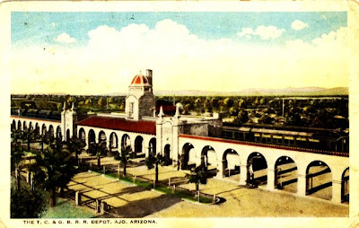
The Tucson, Cornelia & Gila Bend Railroad ran 42 miles of single track from the Southern Pacific at Gila Bend to an attractive mission style depot at one end of the plaza in Ajo.

New Cornelia was always a surface mining operation and the unused open pit is still there of course, occupying almost as many acres as the town site. At first, steam engines pulled gondolas, later, electric locomotives were used.

The centerpiece of the planned community is a palm fringed plaza completed in 1917. At the northeast end was a flagpole opposite the railroad depot, and at the other end a bandstand. Two business blocks were on either side, housing the company store, post office, Oasis theater and shops. This is the block on the northwest side around 1938.

Hispanic, African-American, Asian and Native American families had to live in segregated neighborhoods until recently in most Arizona communities. Most classrooms were integrated until about 1910, then separate classes, teachers and even schools were assigned to students of color until the Supreme Court decision of 1954.

Hotel Cornelia, built in 1916, is located at 300 La Mina Avenue in Ajo. The building was more recently occupied by Cameron Realty and Jon Jon's Day Spa.

Monday, October 19, 2009


A is for Ajo, Alpine and Apache Junction. Arivaca, Ash Fork and Avondale.
Don’t forget Adamana, Ahwatukee and Anthem!
B is for Benson, Bisbee and Bullhead City. Also Bagdad, Buckeye, Bowie and Bylas.
C is for Calabasas, Casa Grande and Chandler. Not to be left out, Cameron, Camp Verde, Carefree, Cave Creek, Chinle, Chloride, Clarkdale, Clifton, Cochise, Colorado City, Concho, Coolidge, Cottonwood and Courtland.
Now we know our Arizona ABCs. We can’t name them all, but we’ve made a start. We’ll go through the alphabet to give short histories of each community. When we reach “Z” we will start over with communities passed over. We begin with Ajo.


"Ajo is where summer spends the winter"

Pronounced AH-hoe, like the Spanish word for garlic, the name of the mining town 42 miles south of Gila Bend may have come from the Papago word for paint, because the tribe collected a copper pigment there [Arizona Handbook(1986)]. Spanish prospectors found rich silver-copper ore there and Americans followed in 1854 after the Gadsden Purchase annexed the site to the USA. Ajo was probably the first copper mine in Arizona [Rock to Riches(1966)].

Early attempts at large-scale production had to wait for better technology and John C. Greenway, manager of Calumet & Arizona at Bisbee and a former Rough Rider with Teddy Roosevelt. He acquired New Cornelia mine stock and set about building a large operation in the remote desert. A railroad was built from Gila Bend in 1915 and a model company town laid out around a classic Hispanic Plaza with buildings in the southwestern mission style, all the rage at the time.

Organ Pipe Cactus National Monument was created in 1937 to preserve a region of the Sonoran Desert south of Ajo. The organ pipe cactus is a saguaro that branches at the ground rather than higher up on a central trunk.

Phelps Dodge acquired the New Cornelia mine in 1931 but had to close it the next year due to falling copper prices during the depression. Reopened in 1934, the huge open pit became the leading copper producer in the state until bested by the Morenci mine in 1943. At first copper concentrates were transported by rail all the way to the C&A smelter at Douglas, but a smelter at Ajo was completed in 1950. Eventually the business cycle again played havoc with prosperity and the mine closed for good in 1985.

Former Phelps Dodge workers now anchor a retirement community and Department of Homeland Security keeps a sizable presence of border patrol agents and customs officers at Ajo. The historic Curley School (1919) was restored in 2007 to become Curley School Artisan Housing. While the last tall smoke stack at the old Phelps Dodge smelter was demolished the same year, some mining continued, with a contractor salvaging precious metals from the old slag pile.

Saturday, October 17, 2009

Arizonac or Arizona?


The American historian Hubert Howe Bancroft (1832-1918) created a publishing company in San Francisco in 1852 that grew into a veritable history factory with a large staff researching and turning out popular histories of western states, including History of Arizona and New Mexico, 1530-1888. One of Bancroft’s maps (above) locates “Arizonac” while another (below) names the place “Arizona.” Spanish officials writing in the 18th Century never used the “Arizonac” spelling, according to Donald T. Garate (see “Arizona Is a Basque Word” posted 10-16-09), even though Arizonac is the plural form of Arizona in the Basque language. The rancho near the 1736 silver discovery was apparently for the first time erroneously named Arizonac on a map drawn in Mexico City.


This postcard from around 1905 shows the lush broadleaf trees and shrubs that grow on the hills and in valleys along small streams around Nogales and extending into Mexico. For modern pictures of the hills surrounding the Arizona ranch in Sonora, see the resource material at Tumacacori National Historic Park website, or the website for Rancho Esmeralda guest ranch. ranchoesmeraldanogales.com/HistoryAll.htm

Friday, October 16, 2009

Arizona Is a Basque Word

“Arizona” is an expression in the Basque language meaning “the good oak tree.” It is used to designate a place where good oak trees grow. Ethnic Basques, whose homeland is the region around the Pyrenees mountains between France and Spain, were among the Spanish settlers in the land of the upper Pimas, or Pimeria Alta in the 17th and 18th centuries. Pimeria Alta would centuries later be within the states of Sonora, Mexico and Arizona, USA.

The region called Arizona became widely known long before it became part of the USA because in 1736 hundreds of pounds of pure silver were discovered laying on top of the ground in the form of balls and flat sheets near “la rancheria del Arizona,” to quote contemporary documents. The Planchas de Plata discovery became a sensation known around the world, and it must have seemed fitting 120 or so years later to name the new US territory Arizona, considering it was still a place of gold and silver mines. But those miners who lobbied for the new territory believed the word to be from the Pima language and they thought the ranch actually established by a Spanish citizen of Basque heritage had been instead a Pima or Papago village, one of the Indian rancherias established by mission padres.

As a result, for the next hundred years, every history book said “Arizona” was likely derived from the name of an indigenous village “Aleh-zone” or “Arison” or “Arizonac,” meaning the place of the little or young spring. It was a believable explanation for Americans who didn’t have access to the original Spanish documents or the Basque language. Documents that never spelled the place “Arizonac,” but instead “Arisona,” or “Arissona,” or more commonly “Arizona.”

Then, more than 20 years ago, Dr. William A. Douglass, Director of the Basque Studies Program at the University of Nevada at Reno suggested that “Arizona” was likely a Basque word applied to a rancho in the oak covered hills of Sonora about 15 miles southwest of the silver discovery and 40 miles southwest of Tumacacori mission. After all, there are or have been other small communities named Arizona, in the US and Latin America as far away as Argentina, and named before there ever was an Arizona Territory. And most of these Arizonas have a Basque connection. And though the Basque term would now be spelled “haritzonak” according to recent orthography, 300 years ago “arizona” would have been the spelling. Donald T. Garate, historian at Tumacacori National Historic Park has researched and verified the theory of Basque origin and written two convincing papers crediting the obscure language used by some of Europe’s oldest inhabitants for the naming of Arizona.

Are all the history books of the past hundred years wrong? It sure seems so if you read the 18th Century Spanish documents quoted by Garate. State Historian Marshall Trimble has been convinced. Will the idea of a Basque origin of “Arizona” spread in today’s Information Age?


[see “Arizona. A land of good oak trees.”(27 pages, 2006), and “Arizona (Never Arizonac)” (33 pages, 2006) by Donald T. Garate; Arizona “The Good Oak Tree” (2 page pamplet, 2007) by A. Badertscher. All are available at the Tumacacori NHP website]
“Arizona. A land of good oak trees.”

www.nps.gov/tuma/historyculture/upload/Arizona%20Article-2.pdf

Thursday, October 15, 2009

Happy 100th Birthday Arizona ! (almost) 1912-2012
Recalling the past hundred years and before—the renown episodes, the forgotten history and the secrets.

Arizona 1912 – 2012
The Sonoran Desert State – The Grand Canyon State – The Mountain Forest State