Monday, February 14, 2011

Part Two:
Arizona Indian Tribes Preserved Their Identities
The first Arizonans lived in the context of distinct tribal identities while intimately mingling across cultural and social lines. That approach to life is still very much evident in the behavior of American Indians today. There are 21 federally recognized Indian tribes in Arizona and a number of “absorbed” and unrecognized populations. Under the pressures of European expansion and preexisting indigenous rivalries, native peoples were forced over the years to relocate, join with neighbors or live on federally designated reservations. This led to much anguish, loss of life and the loss of many traditions.

It is useful, from an observational standpoint, to place tribal identity in the context of spoken languages. Most linguists see all native Arizona languages related to Athabascan, Hokan or Uto-Aztecan patterns. The first Europeans to arrive from Spain named at least 45 different tribes in the southwest, speaking almost as many languages. Fourteen languages were identified in the area that would become Arizona and New Mexico. Later, the Spanish would encounter nearly a dozen Athabascan speaking bands, each marked by subtle differences in dialect. The diverse Athabascan speaking peoples of eastern Arizona included the Navajo and the Apache, often grouped under the Na-dene language subfamily.

Within the Hokan language family were the Yuman speaking tribes, the Yuma, Cocopah, Maricopa and Mohave people, and the Yuman speaking “Pai” people, Havasupai, Walapai and Yavapai. These people inhabited central and western Arizona, many along the Colorado and Verde Rivers.

The Piman languages strongly resemble Uto-Aztecan tongues spoken from California to Colorado and all the way into Mexico and Central America. The Piman speaking tribes of southern Arizona include the Pima and Tohono O’odam people. Northwestern Arizona’s border encloses the southern edge of the Great Basin landscape, home to the Utes and Paiutes whose traditional languages are similar to the Shoshonean tongues, considered a branch of the Uto-Aztecan family of languages.

Also in Arizona are a number of pueblo communities and associated religious sites of the Hopi, Tewa and Zuni people, who, despite similarities in lifestyle and religion, speak distinct languages. The Hopi language seems derived from the Uto-Aztecan, while Tewa is classified Tanoan. The sounds and structure of Zuni speech suggest no linguistic kinship.
Navajo families were matriarchal with the strongest bond between sisters. The husband was expected to avoid his mother-in-law while providing for her family and his mother’s family. The Santa Fe Railway distributed this Kodachrome photo in the 1940s when horse-drawn wagons were still in widespread use on the reservation.

The Navajo Nation (Diné)
Although they speak an Athabascan dialect, Navajos do not consider themselves Apaches, and Apaches concur. Nevertheless, they were called Apache de Nabaju by residents of Jemez Pueblo, who passed the name along to the Spanish. Nabaju means “planted fields,” or “to take from fields” in the Tewa language. The Navajo had recently added small-scale farming to their hunter-gatherer economy. Immediately recognizing the value of sheep and horses introduced by the Spanish, the Navajo had to steal these animals from the Pueblos.

To curtail these raids, early in the 18th century the Spanish encouraged the Navajo to move westward to a region between Zuni Pueblo and the San Juan River and east of the Hopi mesas. By the beginning of the 19th century, Spanish and later Mexican groups were raiding the Navajo, taking child captives to be sold into slavery as domestic servants. In response, the Navajo increasingly adopted a warrior society led by a few respected chiefs. In 1837 Navajos sacked the Hopi village of Oraibi. The US Army came during the Mexican War in 1846 and attempted to end Navajo raiding by military force followed by treaty negotiations. Fort Defiance was established in the heart of Navajo territory in 1851 but had to be abandoned ten years later to fight the Civil War.

When the Territory of Arizona was established in 1863, the military returned to “destroy” the Navajo. The public plan was to kill all Navajo males capable of bearing arms, taking women and children captive. In reality, the military swept across the Navajo homeland destroying the agricultural base and taking prisoners with offers of food. In 1863, 301 Navajos were killed, in 1864 only 23. But around 8,000 prisoners of war were marched 350-450 miles to a bend on the Pecos River called Bosque Redondo near Fort Sumner in northeastern New Mexico. There, along with 400 Mescalero Apaches living as prisoners on the other side of the Pecos, the Navajo were forced to build a town, grow crops and supplement their food with supervised hunting.

Bosque Redondo was a failure. There was never enough food, even though the army purchased expensive provisions hauled from St. Louis. The surrounding area could not supply enough wood for winter. And New Mexico residents didn’t want these terrorists living in their backyard. After quarreling with the Navajo, the Mescalero walked out one night in 1865 and the army let them go. The same year, 2,321 Navajos died of smallpox. Five soldiers were killed in 1867. Accepting failure, the Bureau of Indian Affairs picked a head chief to go to Washington and he returned with a new treaty. In the summer of 1868, more than 7,300 Navajos walked back to their homeland in small groups where they rejoined a couple thousand of their brethren who had eluded capture. The Long Walk to Bosque Redondo and back would never be forgotten by the Diné.

The Navajo religion has no clearly defined supreme being, but the Yei (Holy Ones) can through precise ceremonials assist those in need and bring good things or misfortune. This painting by James Wayne Yazzi (Arizona Highways, August, 1968) illustrates the rare nine-day Nightway or Yeibichai ceremony performed to heal central nervous system illness, or as psychologists would say, “disorders.” Here, on the final night, invited guests surround six impersonators of the Yei in masks, led by Fringe Mouth the clown and Talking God the singer. On the left is the arbor from which the dancers emerged. On the right is a ceremonial Hogan for the patient and five curative sand paintings. If no mistakes are made in the ceremony, order will be restored and the patient will be in recovery. The object of life is to “walk in beauty,” to live in harmony with the world, steering clear of evil and thus enjoying a healthy life.

In order to survive in their beautiful but harsh and remote homeland, Navajos were dependent upon Anglo traders to take in what families produced in exchange for goods unobtainable on the reservation. This is the interior of Hubbell Trading Post at Ganado photographed in the early 1960s by Wayne Davis of St. Johns (Arizona Highways, September 1967). Juan Lorenzo Hubbell (1854-1930) opened the business in 1876, one of several in a string of Hubbell enterprises. After serving as Apache County Sheriff in St. Johns 1882-1886, Hubbell moved to Ganado where he encouraged production of Navajo blankets and rugs. Still in business, the trading post became in 1967 part of a National Historic Site administered by the US Park Service.

Upon return From Bosque Redondo raiding resumed, but farming, herding sheep and raising horses increased. Over the following years, the reservation established by treaty in the Four Corners region expanded many times. It soon became the largest reservation in the country with the most populous tribe in Arizona. After 1873, Navajo wool blankets were an important source of income, with silver jewelry and colorful paintings added by the end of the century. Beginning with a company of Navajo cavalry in 1872, a Navajo police force was organized. Missions and boarding schools came around 1900. But per-family income declined from 1900-1930. In 1917, the BIA began encouraging the formation of local government Chapters on the reservation. From 1925-29, interest groups representing Grand Canyon tourism got Congress to pay for a highway bridge across the Colorado River near Lee’s Ferry by charging it to money appropriated for the Navajos. Oil companies wanted a tribal wide authority to sign oil and gas leases on behalf of all Navajos. An advisory committee organized in 1923 soon became known as the Tribal Council, headquartered at Window Rock in 1936. The first election of Council Delegates was held in 1938. Navajos quickly learned to be clever politicians and skillful bureaucrats. By 1998, there were 110 local Chapters, 183 tribal government agencies, seven judicial district courts and several dozen powerful grazing committees.

But the Navajo Nation still struggles to provide for its people. The BIA instituted a mandatory livestock reduction program in 1934 that led to much grief and forced relocation from Hopi lands beginning in 1970 disturbed many families while adding New Lands to the reservation. The Council removed tribal Chairman Peter MacDonald from office in 1989 on corruption charges, sparking an attempted coup by supporters that resulted in two deaths. McDonald was sent to federal prison in 1990. Pardoned by the tribal Council in 1995, his sentence was commuted by President Clinton in 2001.

I believe this color picture appeared in the Santa Fe Railway promotional magazine for tourists around 1910. Labeled “Apache warrior on the Rio Navajo, Arizona,” it and another view of two Apache riders photographed at the same spot are exciting, if posed, glimpses of indigenous life. Also repeatedly issued as postcards by the Fred Harvey Company, the photos were surely not taken in Arizona. They undoubtedly show Jicarilla Apaches on their reservation in northern New Mexico, where the Navajo River runs out of Colorado and back to join the San Juan. Not far from the location pictured the railroad follows the river, named Rio Navajo and Rio Florida by the Spanish because Navajos lived there. It was not the Santa Fe Railway, however, but the rival Denver Rio Grande, which might explain why the photos would be wrongly identified. By 1968, the rails along the Navajo River lay abandoned but excursion trains continued to run along the line at either end, the Durango and Silverton in Colorado and the Cumbres and Toltec in New Mexico.


The Apache Tribes (Nde, Inde or Nide)
In order to understand historical Apache behavior it is important to note their social organization. Apaches lived in widely scattered but territorial family, joint family or local group communities. Groups formed loose confederations to create bands, with a single leader in an advisory rather than dictatorial capacity. Speaking Athabascan dialects intelligible across bands, each community retained its distinctive identity while freely mingling and intermarrying. Families were matrilineal and matrilocal, but marriages sometimes polygamous. The Western Apache also imposed a matrilineal clan system with kinship determined by 62 clans based on plant gathering areas. Clan relationships transcend bands. Daily life was controlled by a number of verbal and behavioral taboos. Apache religious beliefs, associated with monuments in the landscape, encouraged tapping into powerful metaphysical forces pervading the environment. Gifted individuals, medicine men or female herbalists, could access power for good or evil purposes. The “enemies-against power” that brought success in battle or raiding was considered the strongest.

The Apache were hunter-gatherers with limited agriculture, but had to adopt a raiding economy to survive. A distinction was made between raiding neighbors without aiming to kill, in order to obtain livestock or foodstuffs, and warfare where the object was to kill perpetrators to avenge the death of one of their own. Accordingly, the European death penalty for horse thieves and anti-government insurgents instigated a chain of Apache reprisals. A number of heinous murders of Apache leaders and whole families by American civilians using extremely deceptive tactics, spelled doom for any possibility of peaceful coexistence. A minority of Chiricahua Apaches, unable to find a place to settle down, ended up constantly on the run.

Two of the most difficult aspects of Apache life for Europeans to understand were the great freedom of volition on the part of individuals and the habit of living one day at a time. But those Europeans who understood Apache social structure were able to exploit rivalries and personal hatreds to divide the bands. In order to pacify Apaches, the Spanish offered food and alcohol to draw them in and then gave them farmland near Hispanic towns. These apaches mansos “tame” farmers became an important segment of early Tucson, a political constituency to use against untamed bands. Later, Apache scouts were very effectively deployed by the US Army to track and subdue “renegade” Chiricahua bands.

US Army scouts were more often Western Apaches, but sometimes Chiricahuas too. Scouts achieved pride and respect. General Crook recruited 75 Western Apache scouts in 1871. They were paid a salary but often accompanied the cavalry over long distances on foot. They could draw a uniform or wear their own clothing and collect the uniform allowance upon leaving the service. Like Anglo military personnel they were subject to harsh punishment. Three Apache scouts were hanged in 1882 following the Cibecue incident. Still, most seemed glad to serve. The White Mountain Apache William Alchesay was one of at least 11 Indian scouts to be awarded the Congressional Medal of Honor in the 19th century. The last Apache scout detachment was disbanded in 1923 at Fort Huachuca. The last scout reportedly retired in 1947. This carte de visite by A. Miller, probably from the 1890s, is in the collection of the Smithsonian Institution.

The many Apache sub-tribes and bands have been known by a confusing plethora of names, often erroneously bestowed by the Spanish or Anglos. The Lipan (Ndé), Jicarilla (Tinde) and Kiowa-Apache (Naisha) tribes remained on the plains of Oklahoma, Texas and New Mexico, while warfare with the Comanche drove other Apaches west of the Rio Grande beginning about 1700. The Mescalero Apaches settled in southern in New Mexico. Other tribes migrated to what would become Arizona, settling north and south of the Gila River and becoming known to the white man as Western Apaches, Gila Apaches and Chiricahuas. The Spanish identified the Western and Gila Apache subtribes, from north to south, as Tontos, Coyoteros and Pinaleños. Then to the southeast, the Spanish distinguished between Chiricahuas and Mimbreños living along the Mimbres River.

Americans identified four sub-tribes of Western Apaches living from the Mogollon Rim south to the Gila River, the Tonto, Cibecue, White Mountain (aka Coyotero), and San Carlos Apaches (aka Pinal or Pinaleño). South of the Gila and into New Mexico and Mexico lived four or five bands of Chiricahuas: the Bedonkohe of Geronimo, the Chieahen of Chiefs Cosito and Codahooyah, the Chihenne of Victorio (aka Warm Springs Apaches), the Chokonen (aka Copper Mine Apaches) of Cochise and his son Naiche, and the Nedni (Nednai or Ndendaande) of Chief Whoa in Mexico. But some of these terms were applied across bands. And many Chiricahua families had relatives in more than one band.

In order to police the Apaches and open up land for white settlement, the US government adopted a policy of confining Indians to reservations. Three were created in Arizona for the various Apache bands.
San Carlos Apache Tribe (Dilzhe’e) on the San Carlos Reservation
White Mountain Apache Tribe (Ndee or Nnee) on the Fort Apache Reservation
Chiricahua (Chokonende) Indian Reservation
In the summer of 1871, the US Board of Indian Commissioners authorized the creation of small Indian reservations adjacent to the Camp Apache, Camp Grant and Camp Verde, military posts. Following the Camp Grant massacre, a four million acre White Mountain Indian Reservation was created by executive order of President Grant November 9, 1871 with the Indian agency office located near where the San Carlos River joins the Gila. Camp San Carlos was established there in 1873. From 1873 to 1877 large parts of the reservation were taken away so the land could be mined. December 14, 1872, President Grant created the Chiricahua Indian Reservation out of the southeastern corner of Arizona Territory, extending south from a point east of the Graham Mountains, to encompass the Chiricahua range and the Dragoon Mountains. This same Executive Order established the “San Carlos division of the White Mountain Indian Reservation.”

This gave too much land to the Indians, stifling economic development, argued the newspapers. And it didn’t stop Chiricahua raiding. In 1875, the federal government decided to forcibly relocate all Apache sub-tribes and bands to the San Carlos division, confining them to as small an area as possible. The Chiricahua Reservation was abolished by U.S. Grant October 30, 1876. More than two decades later, long after the concentration policy failed, Congress voted June 7, 1897 to split the White Mountain Reservation into the Fort Apache Indian Reservation north of the Salt and Black Rivers, and the San Carlos Reservation to the south. These days, the Fort Apache Reservation is more often referred to as the White Mountain Reservation.

The Chiricahua people were hit hard by the confinement at San Carlos. General Crook made promises he could not keep and intimidated them with severed heads of renegades on display and threats of prosecution in Indian courts for use of alcohol and polygamy. The Department of Interior, Indian bureau threatened prosecution in civilian courts for religious “devil dancing” and abusing wives. In May 1877, Apaches who tried to return to Warm Springs, New Mexico were forcibly taken to San Carlos. In 1881 several Chiricahua bands fled San Carlos, only to return three years later after they were hunted down by Crook’s troops in Mexico. Geronimo, Naiche, Nana, Mangas junior and Chihuahua led a group of 35 men, 8 teenage boys and 101 women and children to flee again in 1885. But at least three quarters of the Chiricahua stayed on the reservation. Toward the end of summer 1886, surrounded in Mexico, the last free Chiricahuas surrendered to Crook’s replacement, General Miles. They were sent east as prisoners of war for 27 years, at military bases first in Texas, then Florida, Alabama and finally Fort Sill, Oklahoma. General Miles also sent the peaceful Chiricahuas who had stayed at San Carlos, and even the Chiricahua scouts who had led the military to the renegades, into captivity along with the others. In 1913 and 1914 they were finally released, to live near Fort Sill, or on the Mescalero or San Carlos reservations, but not their homelands. The Chiricahua Diaspora persists to this day.
Charles W. Herbert of Western Ways Features took this photo of the White Mountain Apache harvest at Whiteriver around 1960. Hundreds of ears in the husk might be pit barbecued for large gatherings. Here, ears are being dried for winter storage. Both Apache and Navajo families depended on corn, beans and squash combined with meat and numerous wild plants. The Navajo landscape favored mutton, while the Apaches preferred beef. Deer, elk and smaller game animals were hunted. Apaches on the move would eat their horses if need be, but would never eat some animals, especially any that lived in water.

The Western Apaches who had learned to replace raiding with farming and ranching faired slightly better than the Chiricahuas. Tuberculosis wasted Indian populations on all the reservations 1916-1925. The death rate among Indians was 17 times higher than the rate for the country as a whole. Willing to seek work off the reservation, some families saw income slowly improve. In the 1940s and 1950s, both the White Mountain and San Carlos tribes profited from large herds of pure Hereford cattle. As cattle ranching waned, the White Mountain Apaches began building in 1954 a recreation industry on their reservation that became a model for other tribes. When SRP tried to stop them from damming its water to create Hawley Lake, the Apaches used armed guards to keep state officials from serving the injunction. Then they built 26 more recreational lakes, stores, campgrounds and a ski resort.

Tonto Apache Tribe (Dilzhe’eh or Dilzhe’e)
Tonto Apaches spoke a separate Athabascan dialect but were generally fluent in the speech of their neighbors. Four northern Tonto bands are recognized, the Mormon Lake, Fossil Creek, Bald Mountain and Oak Creek. Southern Tonto bands include the Mazatzal and six semi-bands. Because they lived in close proximity in harmony, the Yavapai and the Tonto Apache tribes were lumped together by the military at Camp Verde on the Rio Verde Reserve in 1871, then, four years later removed to the San Carlos Reservation between Globe and Safford. Returning to their aboriginal homeland near Payson a generation later, about a hundred Tonto Apaches struggled to gain title to land. A small Tonto Apache Reservation was established in 1972 and efforts have been made to expand it.

This is a detail from a stereoscopic card labeled “Apache squaws Verde Reservation,” by Dudley P. Flanders. The Los Angeles based photographer made his “Trip Though Arizona” from December 1873 to November 1874. He pictured the Verde Reserve during the spring of 1874. Both Tonto Apache and Yavapai women are likely present in this view. Some of the Yavapai women have multiple strings of beads around their necks, vertical lines on their faces and horizontal white stripes in their hair, distinguishing them from their Apache companions.

The Yavapai people
Three reservations in Arizona were created over the years for the displaced Yavapai people.
Fort McDowell Mohave-Apache Indian Community
The 26,400 acre reservation was created in 1886 at the former military post. Population is now around 1,000.
Yavapai-Apache Nation
Created in 1871 near Camp Verde, the reservation was taken away in 1875 and the residents forcibly removed to the San Carlos Apache Reservation. Re-established in 1909, additional land was added in 1915, 1917, 1967 and 1974, bringing total area to 644 acres for about 1,700 residents.
Yavapai-Prescott Indian Tribe
The 1,395-acre reservation was created in 1935 outside Prescott, but is now home to little more than 150 residents.

Warfare had long ago become a persistent cultural institution for the Yuman speaking peoples of Arizona, driving families into warring factions and splitting communities to scatter over a wider area. The Lower Yumans, the Cocopah, Halchidhoma (aka Xalchidom), Maricopa (aka Cocomaricopa), Mohave and Yuma tribes all probably lived along the Colorado River until the Maricopa people left to seek peace up the Gila River to the east. The Halchidhoma also went up the Gila to its junction with the Salt River in the 18th century. Also probably in search of peace, the Upper Yuman tribes or Pai (“we people”), the Havasupai (or Supai), Hualapai (aka Walapai) and Yavapai went into the mountains and canyons of central Arizona to live.

“The modern Yavapai-Apache Nation is the combination of two distinct Tribal People; the northeast Yavapai (also known sometimes as the Yavape’), some Wipukapaya and Kewevkapaya People and the Dilzhe’e Apache often referred to in books and movies as Tontos or Tonto Apache. Both of our ancestral tribes lived in the Verde Valley and the surrounding country for centuries. The Dilzhe’e lived mostly east of and the Yavapai mostly west of the Verde River, but they overlapped on both sides when they needed to. Along the River Yavapai and Apache families shared resources and even intermarried. A lot of the old timers who grew up in that way spoke both languages.” (Yavapai-Apache KIDSHISTORY-07.pdf)

Ignoring their Yuman-based speech, the Anglos who ruled Arizona, considered the Yavapai just another Apache band, calling them Mohave-Apaches, Yavapai-Apaches or Yuma-Apaches. This led to much suffering on the part of the Indians. As soon as General George Crook assumed command of the military department of Arizona he ordered a roundup of all Apaches in the vicinity who did not voluntarily report to the Camp Verde reservation by a February 1872 deadline. December 28, 1872, 120 US soldiers and 100 Pima scouts trapped a group of Kewevkapaya families who refused to surrender in Skeleton Cave in the Salt River Canyon, mercilessly slaughtering at least 75 men, women and children with gunfire and by rolling boulders down on them. Their mangled bodies were left in place to rot. About 35 wounded women and children were sent to Camp Verde. Then in 1875, the Camp Verde reservation was abolished and 1,500 Yavapais and Tonto Apaches were force-marched to San Carlos where they remained for the next 25 years. In the early 1920s, a few survivors went to Skeleton Cave and recovered bones for proper burial on the Fort McDowell reservation. In 1975, the tribe saved their reservation at Fort McDowell from inundation by stopping construction of Orme Dam.

See:
(Most tribes publish newspapers. In addition, the internet is now one of the best places to hear from Native peoples and their governments and organizations. The forums at www.American-Tribes.com are particularly helpful. For Aravaipa Apache history see, http://interstice.us/apachestelltheirstory/history-early.htm For a portal to everything Navajo go to, www.lapahie.com/ Chiricahua-Apache.com gives the current viewpoint from the Chiricahua perspective.)
The Arizona Blue Book, Arizona Secretary of State (tribal listing)
Arizona Commission of Indian Affairs, Tribal Directory
Gordon C. Baldwin, The Apache Indians, (1978)
Keith H. Basso, ed., Western Apache Raiding and Warfare, (1971)
Kathy Block, “The Skeleton Cave Massacre” (2009) http://apcrp.org/SKELETON_CAVE/Skeleton%20Cave%20Massacre.htm
Timothy Braatz, Surviving Conquest A History of the Yavapai Peoples, (2003)
Karl Jacoby & Patricia Nelson Limerick, Shadows at Dawn: A Apache Massacre and the Violence of History, (2009) about the Camp Grant Massacre.
Broderick H. Johnson, et al., Denetsosie, (1969) the Navajo Long Walk and after.
Sherry Robinson, Apache Voices, (2000)
James D. Shinkle, Fort Sumner and the Bosque Redondo Indian Reservation, (1965)
Dale Slocum, Today With the White Mountain Apache, (1972)
Edward H. Spicer, Cycles of Conquest, (1962)
Eva Tulene Watt, Don’t Let the Sun Step Over You, (2004) White Mt. Apache family life 1860-1975.

Tuesday, January 25, 2011

(background of 13th Century polychrome pottery patterns from Four Mile dig in east-central Arizona, drawn by Mac Schweitzer.)

 
Part One:
Arizona Indians Survived
the Loss of Their World
Arizona’s indigenous peoples left no written archive for historians. Most of what we know about the Native American experience has been documented by Anglos, making tribal history an exercise in western European thinking. Therefore, it is insightful to relate American Indian history from a postcolonial, multicultural perspective. In any case, the profound conflict between Native and European values made Indian life really difficult over the years. When Europeans arrived in the southwest, the people already living there would have been happy to share some tobacco over a campfire. Instead, they were surprised and dismayed to learn that these strangers shared nothing.

This encounter happened at the height of the Renaissance and Reformation in Europe. It was not an age of tolerance. And Spain in particular was still acting out the horrors of the Inquisition. European civilization was structured along class lines, with an aristocracy and monarchy that demanded complete fealty. Science and the Reformation challenged the Catholic Church. Merchants and new technologies offered an alternative to the accumulation of wealth via Feudalism. It was an age of conflict. And it had become accepted in the eastern hemisphere that the strong should dominate the weak.

Europeans enforced real property ownership on Indians who saw no property lines on the ground and had difficulty understanding the concept of possession of dirt by absentee owners. Conquistadors demanded obeisance by conquered tribes to a king Indians would never meet. Padres tolerated no unorthodox rituals or beliefs, destroyed idols and required families to perform forced labor that benefited the aristocracy and the religious order. Conscientious objectors were subjected to torture, hanging, garroting, beheading, dismemberment or amputation. It must have been obvious early on that Europeans considered Indians an inferior conquered population. And yet Indians were shy but proud, placing great importance on personal respect. The clashing of conflicting beliefs initiated several centuries of Indian rebellions and European punitive expeditions.

The Apache practice of killing whole families or taking women and children captive spread fear and inflamed Anglo resentment. With great difficulty, the US military disarmed and confined each renegade band, culminating in the surrender of Geronimo’s Chiricahuas in 1886. Just before the official surrender, Tombstone photographer C. S. Fly set up a series of poses like this one of Geronimo and his still armed families. Six months earlier in New Mexico, 11-year-old Santiago “Jimmy” McKinn rode off with the Indians as they killed his older brother. The two boys were away from home caring for horses and the Apaches needed more horses. After the surrender, Santiago, who already spoke English and Spanish, was returned to his father fluent in Apache. Geronimo and his men, women and children were sent east for 27 years of confinement. Santiago grew up to become a blacksmith in Silver City, New Mexico. Later he moved with his wife and children to Phoenix where he died in the 1950s. The boy with bow and arrow has been identified as Garditha, a 10-year-old orphan who became the uncle of the influential Fort Sill leader Robert Gooday. There is an accompanying photo showing Garditha and the other boys brandishing rifles along side the men. It is believed he died during confinement in Florida or Alabama. The man in white shirt, sitting at right may be the 20-year-old Zhonne, brother-in-law of the leader Natchez (Naiche). In several of the photos he is holding his baby. Zhonne was sent to Carlisle Indian School in Pennsylvania for rehabilitation where he is later pictured with short hair in a stylish suit. As Calvin Zhonne, he was eventually reunited with his wife and children and they went in 1913, the year imprisonment of the Chiricahuas ended, to live on the Mescalero reservation in New Mexico.

The practice of pagan rituals was proof to the white man of the need for change in Indian behavior. Fervent and persistent missionary efforts were introduced on every reservation to persuade natives to turn away from the devil. It was an exercise in liberal idealism, a belief in repentance and rehabilitation. As late as the 1950s, when Mike Roberts issued this postcard, many were still calling this ceremony the “Apache devil dance.” The White Mountain Apaches call the men Gann dancers or crown dancers. Representing the life within the living mountains, the Gann appear at many ceremonies. They are seen here as part of the Sunrise Ceremony, a puberty rite for girls. While many Apaches have become devoted Christians and church members, traditional practices continue.

Adventurers from the United States eventually took possession of the southwest by military force and imposed their own liberal democratic ideals. The land, its animals, minerals, plants and people, was an economic resource that must be used to further the progress of civilization. Native peoples became wards of the state, confined to government reserves for their salvation and education. A debate ensued, between those who advocated extirpation and those who argued for assimilation. Democracy demanded that any resolution of that debate remain tentative. Those who rejected liberal ideals supported violent solutions like the infamous Bascom Affair and the Camp Grant Massacre.

San Carlos Indian Agent John P. Clum summed up the military war against the Apaches from 1862 to 1871 as more than $38 million spent to kill less than 100 Indians, including old men, women and children, at the cost of the lives of more than 1,000 Anglo soldiers and civilians. (p. 67, Baldwin, The Apache Indians, 1978) Then in 1871, about 125 Aravaipa Apaches, mostly women and children, were massacred by Tucson vigilantes while living under the supervision of the military at Camp Grant. It has been estimated that several hundred Yavapai Indians, mistaken for Apaches, were killed between 1864 and 1876, including at least 75 slaughtered at Skeleton Cave in 1872. Unfortunately, the expense and killing would continue until at least 1886. And the economy of Arizona Territory suffered. Finally, with the appointment of General Crook to deal with the Apache problem, the great Arizona copper magnate James Douglas noted that resolution was finally at hand. “The true remedy lies in supplying the Indian with the means of supporting himself and training him to live side by side in healthy rivalry with the white man, not in fostering race distinction by isolating the Indian on his reservation and excluding the white man from mines that the Indian cannot work and pastures that he cannot occupy.” (pp. 78-79, H. H. Langton, James Douglas A Memoir, 1940)

In a harsh environment, hunter-gatherer tribes had to be constantly on the move, often taking from others what they needed to survive. For many years after they were confined on reservations, learning to farm for a living, they were dependent upon food bank handouts from the federal government. This detail from a stereoscopic card by Rothrock of Phoenix shows “count” and “ration day” on the San Carlos Apache Reservation about 1878. The people would be counted to ensure none had left the reservation and then issued European foodstuffs. In recent years there has been a drive to reintroduce traditional foods in the Native American diet in order to treat obesity and diabetes.

At the end of the Indian wars, the prevailing idea, irrespective of the facts, was that Native Americans were a dying race, with their only hope that of integration into American society. Government Indian boarding schools were instituted toward this end, and Phoenix had one of the biggest. This is a view of a Phoenix dormitory in the 1890s. Some old postcards call this the “Boys Hall,” while others label the same view “Girls Dormitory.” Phoenix Indian School was established in 1891 and closed in 1990. Historical archaeologist Owen Lindauer has commented, “Many students were forcibly separated from their parents, and the rapid personal transformation demanded of pupils was facilitated through a draconian and abrupt detachment from tribal cultural patterns.” (“Archaeology of the Phoenix Indian School,” March 27, 1998, Archaeological Institute of America)

Phoenix Indian School was big on band, sports and military classes. This is a group of officers with their Anglo commander about 1912. Many Native Americans seemed to welcome military life and became heroic soldiers and marines. A group of Geronimo’s warriors were recruited for Company I, 12th Infantry, US Army. Previously, Apache and Yavapai army scouts were General Crook’s secret weapon against Geronimo. Actually, rather than secret they became storied, remaining a part of the Army Signal Corps into the 1920s. And then the use of code talkers during World War II has recently become equally legendary.

This is a classroom in a Hualapai school near Kingman around 1900. They look glum, but even Anglo children knew it would be rude to smile for the camera in those days. And their rather rude classroom was probably no worse than many Arizona rural school buildings at the time. Those are maps of the continents decorating the walls above the hat pegs. (click on photo to see full size) In 1900, many Anglo kids couldn’t afford shoes either. This is likely a day school instead of a boarding school. Still, most Indian schools failed to produce fully integrated citizens. In the words of former Commissioner of Indian Affairs Francis Leupp, writing in 1910, the Indians did not fail in their quest for an education but the schools failed the Indians. (p. 129, Dejong, Promises of the Past, 1993) Well educated Natives Americans would continue to have difficulty competing in the job market, excelling at liberal politics or finding happiness at home in a country where half of all marriages fail.

In the end, European civilization came to dominate the western hemisphere. Jared Diamond (Guns, Germs & Steel, 1997) has shown how chance circumstances of geography denied Native Americans the usefulness of steel tools, animals capable of domestication and warriors with the force of gunpowder. Indigenous Americans were certainly intelligent and clever enough and their ideals were no more debilitating than the Machiavellianism and chivalry of the old world. As soon as they got their hands on horses, sheep and cattle, knives, guns and badges, Native Americans quickly demonstrated their skill with these implements.

The Indian Citizenship Act of 1924 (Snyder Act) granted full US citizenship to Indians. That didn’t mean they could vote. Voting rights have never been accorded all citizens in the US. The Indian Reorganization Act of 1934 established a framework for tribal government on reservations. Native Americans would now be able to elect tribal leaders. The service of ethnic minorities in World War II opened the door to participation in civil society following the war. When Native Americans were refused voter registration in Arizona because they were “wards of the government” they went to court and won a judgment in their favor July 15, 1948 in the Arizona Supreme Court. County election officials then turned to literacy tests to disqualify Indian voters. Local governments found ways around the Voting Rights Act of 1965, which outlawed discriminatory practices. When the first Navajo was elected to the Apache County Board of Supervisors in 1972, the Anglo supervisors refused to certify his election. Again, the Arizona Supreme Court ruled in favor of Indian electoral rights. (109 Ariz. 510, 1973) But disqualification of ballots, voters and candidates on technicalities continues.

The Quechan or Yuma people operated a ferry service across the Colorado River at Fort Yuma for forty-niners going to California. Anglo entrepreneurs then started a competing ferry. When the Quechan tried to block access the Anglos got the military to intervene. Belligerent Indians ran the troops out of the fort for a year, but soldiers returned and put the Quechan out of business for good. As Yuma’s commercial district grew, its indigenous residents were criticized for indolence and alcoholism. In this view from about 1910 with the Southern Pacific railroad depot and hotel behind the trees, a few industrious women offer train passengers their crafts. The train is just out of view at left.  The little house with lots of windows is a produce exhibit.  This was when the SP main line crossed the river near the old quartermaster depot and went down the middle of Madison Avenue. The bridge, depot and tracks were removed from 1927-1966. Recently this whole area of Yuma was bulldozed for development, leaving it completely unrecognizable as a historic district.

Many of Arizona’s natives produced works of art with great value. Navajo blankets, Pima baskets and Hopi pottery were admired around the world after display at a number of international expositions. This unnamed Hopi woman appears to be making everyday utilitarian vessels rather than the highly polished and finely painted pueblo ware produced during the same time period. Her clay has been ground on a stone and mixed in a bowl and the pot is fashioned from coils. The picture is a colorized black & white photo copyright 1899 by Detroit Photographic Company, which issued it as a postcard.

After a couple bloody rebellions, most of the Tohono O’odam people eventually embraced the Catholic church and labored from 1783 until 1797 building this still astonishingly beautiful work of colonial architecture, Mission San Xavier del Bac, south of Tucson. The architecture has been attributed to Ignacio Gaona but there is no documentation. Padre Kino, who first visited the area in 1692, established the mission in 1700 at a site two miles from the present church. Following the creation of the Mexican republic, the friars left in 1828, not to return until 1911. During that time, faithful Tohono O’odam caretakers preserved the building. This postcard view shows the church after repairs were completed in 1906 following an 1887 earthquake. (Celestine Chinn, Mission San Xavier del Bac, 1951)
See:
Judith Harlan, American Indians Today, (1987)
Robert H. Jackson, Indian Population Decline, (1994)
Levin & Lurie, eds., The American Indian Today, (1970)
Richard C. McCormick, Arizona: Its Resources and Prospects, (1865)
Edward H. Spicer, Cycles of Conquest, (1962)

Monday, December 27, 2010

Roosevelt Survived the Flood

The town of Roosevelt is a service point for recreation on Roosevelt Lake, but it started before there was a lake, to provide goods and services to the workers building Roosevelt Dam. Back then it was located on the riverbank below the planned reservoir level. And as water rose behind the dam, the town had to move to higher ground to survive the flood. In fact, the lake rose behind the dam so rapidly during the spring of 1908 that many of the buildings were submerged before they could be moved, only to reappear during low water levels in the 1930s.

When construction workers first came in 1903, the project was called Tonto Dam or Tonto Basin Dam, after the valley that holds the lake. The dam would be built where the river was squeezed to 200 feet as it entered a rugged canyon just below a point called “The Crossing.” Exactly when the town came to be named Roosevelt is not clear. There is evidence that it was first called Newtown. But the Post Office was established January 22, 1904 as “Roosevelt,” and probably by then everyone knew it would be called Theodore Roosevelt Dam, after the president who supported its construction.

Looking west across a lazy Salt River about 1905, the dam site is in the canyon at right, with the town of Roosevelt spread across the only flat ground above the river. In another three years it would be inundated by the reservoir. Above the lake level, on Government Hill at left, are Reclamation Service buildings and tents for unmarried engineers. The largest building in front is the dining hall. The power canal is winding around the hills toward the damsite. On the hill at center is the cement plant. On the hill across the river is dam contractor O’Rourke’s camp. (I have added color to black & white photos for this post)

Looking NE over the town of Roosevelt in 1905, toward the frosted Sierra Ancha range, the main street business district is visible at the right edge. (click on picture for full size) Most of the houses are canvas tents with wooden walls and floors. In the lower left foreground is the electric plant, with a glimpse of the Salt River behind. East of town a road crossed the Salt and went 30 miles into the Sierra Anchas where the government built a sawmill to supply the project with at least three million board feet of lumber.
After 20 years of agricultural development beginning in 1867, many fortunes had been made in the Salt River Valley. But just as the ancient indigenous people who eventually abandoned their canals had learned, life in the irrigated oasis was always threatened by flood or drought. The spring freshet of 1886 washed out Arizona Dam at the head of the Arizona canal. Then the great flood of 1891 that put knee-deep water in the streets of Phoenix washed out all the dams on the Salt River. And as soon as the water drained away a period of severe drought set in until the end of the century.

Far-sighted individuals had already concluded there was need of a storage reservoir in the canyons of the Salt River, and the ideal site had been located in 1889, just below the confluence of the Salt with Tonto Creek. Despite agricultural bounty in the Valley, however, funding for such an ambitious project fell short. Private efforts failed twice. Meanwhile, flooding returned in 1900, only to be followed in 1901 by an all-time low level of water in the Salt River. Mass meetings were held in Phoenix’s Dorris Opera House and appeals were made to friends in Washington D.C. After Congress rejected the sale of Maricopa County bonds it provided a solution to the funding problem in the form of the National Reclamation Act, signed by Republican President Teddy Roosevelt June 17, 1902. It came at a time when the federal government was expanding its involvement in the states and the United States had become an imperial power to rival the empires of Europe.

Using the pooled resources of taxpayers across the country, the US Reclamation Service would provide millions of dollars to build the tallest dam in the country and the largest reservoir in the world, to block floods yet keep Salt River Valley canals full. It would be called the “Salt River Project,” the first of many reclamation projects in Arizona and among the first five in the country. Eleven private canal companies in the Valley were united in February 1903 to form the Salt River Valley Water Users Association, a non-profit irrigation company. Farmers and ranchers pledged to pay back the federal government loan, putting up their land as collateral. Hydropower generated by water releases at the dam would subsidize water delivery, with enough excess power to pump ground water beyond the end of canals. None of this came without opposition, but the majority prevailed.

This map prepared in 1910 by the Reclamation Service shows the site about 1907, but with a completed dam as it would appear in 1910. The main street of Roosevelt is at upper right, with the USRS office on Government Hill just below. Dam contractor O’Rourke’s camp is across the river by way of a suspension footbridge that washed away in 1908. The steam power plant, cement mill, sand crushing and concrete mixing plants are located. The power canal brought water to a temporary hydroelectric turbine located inside the penstock tunnel, putting the more costly steam plant on standby.

 
Roosevelt Dam was located in a very remote canyon 40 miles from the railroad at Globe and about 60 miles from Phoenix, inflating the cost of freighting supplies and adding to the difficulty of construction. Contractors reached the site from Globe in 1903, while construction of a road from Mesa, to be called the Apache Trail, continued for another three years. Houses for workers and a few stores were built on a hillside within walking distance of the dam site. The town and O’Rourke’s camp were provided with water and sewer lines, an ice plant, telephones and electricity. Roosevelt had utilities other towns in Arizona wished for. It also went without something every other boomtown had. The government forbade the sale of alcohol. Brick and lime kilns were completed in 1904, the same year a telephone line was strung to Phoenix and the road from Globe was completed. Work had begun on a cement plant. John M. O’Rourke & Co. of Galveston, Texas won the low bid to construct just the dam in March 1905 for a cost reported in the press of $1.1 million.

Though small and primitive motor trucks were available after 1905, large teams of draft horses or mules were still the best way to transport heavy loads beyond the railroad until well into the 1920s. All supplies for the work camp and construction were hauled over the shorter and relatively easier grades from Globe or the long and steep road from Mesa. The last two miles of the Mesa road were not completed until 1905. Freight made up 30% of the cost of supplies. Here, an empty oil tanker has stopped on the Apache Trail at J. Fraser’s Road House, a lodge at the bottom of Fish Creek Hill, before starting the difficult climb on the way to Mesa. (The postcard was published by the Berryhill Company of Phoenix and printed in Germany about 1907. Within a year or two American printers would install German presses and offer color postcards at a competitive price.)

So cement would not have to be freighted from Globe or Mesa, the Reclamation Service built (Nov. 1903-Mar.1905) a cement mill overlooking the damsite. Using limestone quarried right at the mill and clay from a mile away, the plant produced 338,452 barrels of cement from April 1905 to July 1910, for a savings of about $600,000. The mill used electricity and fuel oil, a barrel of oil for each four barrels of cement produced. The cost saving allowed the government to also ship barrels of cement from Roosevelt to the construction site of Granite Reef Dam in the Valley. A fire in the cement mill on December 7, 1908 caused a lot of damage and stopped work on the dam for two weeks.

To provide electricity, first a small wood-fired plant was built. It required 25 cords of wood a day and all scrub trees were soon stripped from the hills for ten miles around. An oil-fueled electric plant started up when oil delivery became available by mule wagons over the road from Mesa. Ultimately the plan was to use hydropower, and work began on a 19-mile power canal with 21 tunnels and two inverted siphons from a diversion dam on the Salt River. But it soon became apparent that the project would cost much more than first estimated. The power canal originally allotted $188,360 for construction gobbled up $1.4 million, plus another $127,000 for the diversion dam.

A 480-foot diversion tunnel, that could be used later to sluice silt from the lake, was bored through the south wall of the canyon in 1904. Cofferdams were built to isolate the worksite and the riverbed was excavated to bedrock over the winter of 1905-1906. In November 1905 came a flood of Biblical proportions. The river rose nearly 30 feet in 15 hours and overtopped the cofferdams. It became apparent that the diversion tunnel was too small and nothing could be done to prevent water from inundating the work every time the Salt River rose to flood stage. After years of drought, construction had unfortunately begun at the start of a period of record stream flows. Finally, the first stone was placed on clean bedrock September 20, 1906. Two months later work halted as the foundation stones disappeared beneath the raging river. Laying stones resumed in June 1907, interrupted by floods in summer and fall. While two years had originally been allotted for construction, four years, seven months and 21 days would pass before stones reached 150 feet on only the south side. It would require six years to complete 280 feet of masonry running 723 feet between spillways.

Here, on July 16, 1906, workers are rebuilding the downstream cofferdam, using a “hydraulic lift” much like a canal lock, to lift excavated material. Digging reached bedrock 30 feet below the river surface where foundation stones were laid in cement mortar on the thoroughly washed bedrock. In December, the Salt River flooded, overtopping the cofferdams and washing away everything seen here. But the cemented stones didn’t budge.

A close-up of construction late in 1907 shows how the dam was engineered. The masonry technique was termed “broken range cyclopean rubble,” placing large irregular blocks of sandstone weighing up to 10-tons each with the joints breaking rather than aligned. Each block was completely surrounded with at least two inches of concrete, with spalls (splinters of rock) added to fill wide gaps. Workers are adding another block at lower right with a tub of concrete at ready, as an engineer in white shirt and tie observes. Pipes deliver water to drench the stones and keep the concrete from drying before it sets. Blocks at the vertical upstream face were finished with a chisel to produce a uniform wall with random projections. Blocks were finished where they made the sloping downstream face to present an aesthetic stair-step surface. (This picture is a detail from a postcard made by German printers who colorized a black & white photograph sent to them by publisher M. Rieder of Los Angeles. Each card coming from a two-color press had additional colors laboriously added by hand with a brush and bottles of dye.)

After two years of frustrating work between floods the project was way behind schedule. Here, on April 29, 1908, sandstone blocks are about 50 feet above bedrock on the south side. But the river is running over the north side while the sluicing tunnel is closed off (bottom left) to install gates from January 31 to July 2. Behind the masonry rubble the hydropower house can be seen. High on the canyon wall at right stones are quarried, then moved by overhead cable and derricks to their place on the dam. The quarry will become the north spillway. An overhead cableway (two black squares are pulleys) delivered stones each night, tubs of concrete mortar all day. The concrete mixing facility is on the side of the canyon at left. The High Line road to Mesa (later called Apache Trail) is precariously cut into the cliffs above the river.

A view of the dam from downstream in late summer 1908 shows the south side rising above 70 feet and work restarted on the lower north side after the sluicing tunnel reopened. The powerhouse is enclosed and water can be seen exiting the tunnel below the building. December 16, 1908, water again overtopped the dam, a stream 125 feet wide and 13 feet deep, not receding until the end of the month. Again, the deluge came so suddenly workers could not save derricks and winches from being swept away.

The sluicing tunnel was closed off again May 8, 1909 so concrete and steel lining could be added to repair cavitation damage. Shutting off irrigation in the valley during the growing season was unacceptable, so workers had to cut a notch in the dam to pass enough water for the crops. Masonry has passed the 130-foot level on the south side and an electric substation building has been added in the foreground. The cableway at upper right is delivering a tub of concrete. The boardinghouse at O’Rourke’s camp can be seen on the hill behind the dam.

By November 1, 1909 the dam was almost 200 feet high on the south side. A week later the sluicing gates would reopen, diverting the river from flowing through the notch on the north side so work could resume there. Stonemasons were working on an ever-narrowing summit. The dam was 167 feet thick at bedrock but only 16 feet at top, enough weight of rock to easily hold back the weight of water 270 or more feet deep. In this photo you can clearly see the vertical upstream face with random projections and the stair-step downstream face. Workers living at O’Rourke’s camp reached the town of Roosevelt by boat after a footbridge suspended across the canyon washed away. They went to work by crossing the notch on the smaller footbridge at lower right.

Immigrants were welcomed as cheap labor in the United States in those days and many different nationalities, including native-born Blacks, worked at Roosevelt. Italians were adept stonecutters. Apache men did much of the work on the road that would later be named after them, proving particularly skillful at laying dry masonry to support the roadbed on the side of cliffs. Still, a strict segregation of labor was maintained, with Anglos in supervisory positions and people of color assigned manual labor.

The temporary hydropower plant provided electricity from April 1906 until August 1909. At that time the permanent hydropower plant constructed (1906-1908) of stone on the south side of the river started up three turbines. In October 1909 electricity was supplied to Valley cities over a 75-mile, 45,000-volt transmission line constructed 1907-1909. Water was supplied to Valley canals at Granite Reef diversion dam (constructed by the Reclamation Service Oct.1906-Aug.1908).

Cost of the dam had ballooned past $3 million, far above the original estimate of $1.9 million. Add to that the expensive power canal, at least a million dollars spent acquiring land and another $2.3 million for the electric power system. “Because of heavy flooding that wreaked havoc with the construction site, it may have been impossible for any company or organization to have built Roosevelt Dam in a timely, cost effective manner,” concluded an official history (Billington, et al., 2005). Flooding showed the need, but residents in the Salt River Valley became impatient for completion and unhappy with Reclamation Service performance and looked for ways to reduce the cost they would have to repay. The last stone on the dam was finally laid February 5, 1911, but O’Rourke’s workers had already begun leaving during the previous year.

After signing the Reclamation Act, President Theodore Roosevelt was reelected in 1904. He declined to run again in 1908 but remained a popular and influential public figure. Here, he arrives from Phoenix by car March 18, 1911 with Territorial Governor Richard Sloan to dedicate the government dam named in his honor.

When the United States entered World War I in 1917, army guards were assigned to prevent sabotage of important infrastructure, including the nation’s largest hydroelectric dam in the remote mountains of the newest state. This detail from a Keystone View Company stereoscopic card shows a contingent of “Sammies” near the south end valve house.

Another two generators were added at Roosevelt Dam in 1912, and spillways were raised five feet in 1913. A sixth generator was added in November 1915. After five years only half full, rain in the mountains filled the lake to 225 feet at the dam and water first began to flow through the spillways on the evening of April 15, 1915. Repairs to the spillways were made from October 1915 to January 1916, and completed just four days before the next spillover. Roosevelt Lake reached a maximum storage of 1.5 million acre-feet, and 2.1 million acre feet were measured over the spillways from January 18 through May 30, 1916. The water level almost touched the underside of the automobile bridges on each side and the dam shook for weeks as if by an earthquake under the weight of water eleven and a half feet deep rushing through the spillways.

Though mailed in 1921, this postcard probably shows the 1915 spill when water first overflowed the dam. The former O’Rourke camp, now Roosevelt Lodge, is at Hotel Point. After overflowing in 1915 and 1916, Roosevelt Lake overflowed again in 1920 before entering a long period of drought. Following the installation of three penstock valves before 1920 in the north canyon wall, water could be released through the south wall sluicing tunnel, hydropower turbines, the spillways, two north wall tunnels and the penstock valves. But the appearance of the dam had been designed to suggest strength under all that weight of water.

Upon completion of the dam, buildings at O’Rourke’s camp were sold to local merchants M. C. Webb and his son. The boarding house became Roosevelt Lodge to accommodate tourists as the sights along the Apache Trail were publicized far and wide. Visitors could ride a bus over the Trail and eat or stay at Tortilla Flat, Fish Creek Lodge or Roosevelt Lodge. Apache Indian families were put on display and Anglo traders sold Native American crafts. In addition to the dam, tourists could visit nearby Tonto National Monument ruins or take a boat out on the lake.

In 1917, the Southern Pacific railroad purchased the hotel and renamed it Apache Lodge. While the Union Pacific railroad bused tourists to the north rim of the Grand Canyon and Santa Fe railroad trains went directly to the south rim, the Southern Pacific promoted Apache Trail and Roosevelt Lake. Railroads also connected with bus and car transportation to a number of Arizona dude ranches and hot springs.

The final cost of the project came to more than $10 million and the ten-year repayment schedule had to be extended to twenty by an act of Congress in 1914. In 1917, the Reclamation Service turned over operation of Roosevelt Dam to the Water Users Association, retaining mortgage holder interests. But the Association could not make loan payments during the recession years of 1920 and 1921. As soon as the economy improved, the Association sold bonds to build five additional dams on the Salt and Verde Rivers beginning in 1923. That same year, spillway gates were added to Roosevelt Dam, raising the lake another 15 feet, and in 1936 spillway floors were improved to minimize damage during overflow. By 1925 irrigation and power infrastructure represented an investment of more than $23 million. In 1937, the Association created the Salt River Project Agricultural Improvement and Power District, an autonomous government entity, so the state legislature could grant it favorable municipal bonding powers. Drought nearly emptied Roosevelt Lake by June 1940. Then it quickly filled and spilled over in 1941. After World War Two, the Association had trouble paying taxes, so it transferred the electric utility to the tax-exempt District, creating today’s SRP. In 1955, water users paid off the federal loan thirty-five years late.

Thaddeus T. Frazier opened a store at Roosevelt in 1908. It hosted the Post Office for many years, with Stella Frazier as postmaster 1916-1958. (The postcard was published around 1952 for the Fraziers by Norton Louis Avery & Son of Lowell, Michigan and printed in “Genuine Natural Color” by Dexter Press of West Nyack, New York.)

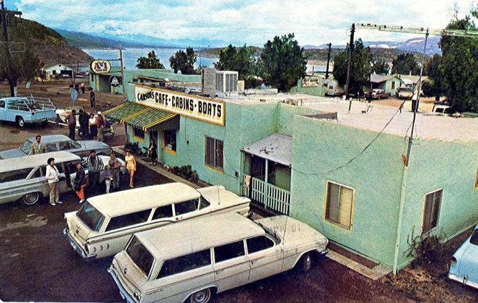
Carson’s Café, cabins and boats was located on the west side of Cottonwood Creek or wash, where the marina is now. This postcard shows the resort about 1962, with Rock Island behind the trees and the highway cut going around to Government Hill visible at upper left. In 1988, work began to reroute Highway 88 and relocate recreational facilities in anticipation of higher reservoir levels after the dam was raised. As a result, only traces of older facilities can be seen today. But again, Roosevelt survived the flood.


The need for more water, earthquake protection and a calculated increase in the volume of “hundred-year floods” caused the federal government in 1984 to authorize raising the height of Roosevelt Dam. Work started in 1989 but had to be delayed when the Salt River again produced a torrent. Storms in the watershed brought the lake to its highest level ever on January 19, 1993. The south spillway could not channel all the flow and water overtopped the sidewall and began pouring onto the roof of the hydropower house, causing a million dollars damage. By then a new 1,080-foot long suspension arch highway bridge had opened behind the dam. When work resumed on the dam, the front was covered over with concrete to thicken it and raise it. At a cost of $424 million the top of the dam was raised 77 feet. Now, only at low water levels can the original sandstone blocks be seen on the upstream wall. Since the original structure had disappeared, the dam’s National Historic Landmark status designated in 1963 was withdrawn in 1999.


See:
Donald N. Bentz, “The Doomed City” Frontier Times May 1968.
David P. Billington, et al., The History of Large Federal Dams. . . (US Bureau of Reclamation, 2005)
Kathleen Garcia, Roosevelt Dam (2009)
Athia L. Hardt, ed., Arizona Waterline [1989]
L. L. Lombardi, Tortilla Flat Then & Now (1996)
Salt River Project, The Taming of the Salt (1970)
Stephen C. Shadegg, Century One (1969)
Chester W. Smith, “The Building of the Roosevelt Dam” The Earth August 1909
Karen L. Smith, The Magnificent Experiment, Building the Salt River Reclamation Project, 1890-1917 (1986)
US Dept. of Interior, USGS, US Reclamation Service, annual reports: 1903-04, 1915-16.
Earl A. Zarbin, Roosevelt Dam: A History to 1911 (1984)

Monday, November 29, 2010

Quartzsite Was In the
Center of Everywhere

The small town of Quartzsite is sprawled out about 5 miles along Interstate-10 in western La Paz County, 19 miles east of Ehrenberg. It extends another five miles north and south of the freeway along State Route 95, which follows Tyson Wash across the La Posa Plain north to the Colorado River. The open desert sizzling in summer heat, surrounded by jagged mountains, gives the impression of a way station in the middle of nowhere, but the estimated 1.5 million yearly visitors suggests Quartzsite is the center of everywhere. Residents have been able to make the location on a well-traveled route pay off in a big way while providing visitors with a memorable experience.


History tells us Charles Tyson built a non-military fort at the location in 1856 to protect the water supply from Mohave-Apache (Yavapai) raids. That was the year of the first rush to the gold placers in Yuma County, and very early in the area’s history, leaving little documentation now. Arizona Territory was not separated from New Mexico until 1863. A historical marker at the site gives 1864 as the probable date Tyson hand dug his well. The Quartzsite Historical Society believes Tyson built the still extant adobe stage station in 1866. That year, the California & Arizona Stage Company began running passengers, mail and Wells Fargo express from the end of the Southern Pacific track in California to Ehrenberg and Wickenburg. Ehrenberg, Arizona was a steamboat landing on the Colorado River, supplying the interior via freight wagons. The river towns of Ehrenberg, Olive City and La Paz served miners during the 1860s Colorado River gold rush. Gold had also been recently discovered around Wickenburg and in the mountains south of Prescott. The stage road forked at Wickenburg, with stages going north to the territorial capital at Prescott and south to Phoenix and Florence.

There are four or five types of desert in Arizona. Quartzsite is near the northern limit of the Sonoran Desert, with the Mohave Desert to the northwest. To the southwest, the landscape differs from the desert around Phoenix and Tucson. Traditionally, this sparse cover in Yuma County and southern California has been called the Colorado Desert, though some authorities say it’s still part of the Sonoran. The Chihuahuan Desert also extends into Arizona around Douglas and San Simon. And parts of northern Arizona along the Utah border resemble the Great Basin Desert. Burton Frasher of Pomona published this Real Photo Post Card, likely in the 1940s.

Frasher also preserved this view of Tyson’s Well stage station looking SE with the highway in the foreground. It may not have been called a fort until the 20th Century. Plaster on the walls and a metal roof has helped preserve the long-abandoned adobe structure.

This photo of Tyson’s, looking northwest at the back of the building, probably dates to the 1940s. Additions without the metal roof are crumbling. The tip of the saguaro cactus in Frasher’s photo is visible above the roof at right. Photographer Glenn Edgerton carefully documented much of the Mohave Desert of California and Arizona.

Tyson’s Well stage station continued to provide rest and refreshment to travelers and freight drivers until the railroads came in the 1880s. Martha Summerhayes, wife of an Army officer stationed in Arizona, described travel in those days. Transferred with her husband from Camp Verde to Ehrenberg, she found way stations along the road primitive but welcoming, with one exception. After three days, the Army wagons entered the Colorado Desert and stopped for the night at Desert Station in Bouse Wash. She again found accommodations “clean and attractive, which was more than could be said of the place where we stopped the next night, a place called Tyson’s Wells. We slept in our tent that night, for of all the places on the earth a poorly kept ranch in Arizona is the most melancholy and uninviting. It reeks of everything unclean, morally and physically.”

Tyson’s Well revived in the 1890s when more efficient gold mining methods were introduced to the area. Several families opened stores, taverns and hotels to serve nearby mines. A post office was established as “Tyson’s” in the summer of 1893 but discontinued in the fall of 1895. A year later the post office reopened under the name “Quartzsite.” Quartzite (without the “s”) is a rock of firmly cemented quartz grains. Lacking experience in prospecting, the postal service apparently registered the name as a place where quartz is found.

But the mining boom soon faded and there were less than 20 residents by 1900. Location again came to the rescue about ten years later when the Atlantic and Pacific automobile road was routed through Quartzsite. Cross-country travelers could avoid the Imperial Sand Dunes west of Yuma by heading from Phoenix to Wickenburg, Quartzsite and Ehrenberg. There, they crossed the Colorado River to Blythe on a small ferry boat and went on to Los Angeles. Every year after 1911 more and more cars made the trip.

Looking east about 1915 along the Atlantic & Pacific Highway through Quartzsite, the Hagely Hotel is on the left. German immigrant Anton Hagely (1844-1928) worked as a butcher in town during the 1890s mining boom and stayed on to become owner of a store and hotel. Upon his death, his wife Victoria continued the business. Their son John George (1894-1977) became a Quartzsite Justice of the Peace. Down the street on the same side, with windmill and water tank out front, is Charles V. Kuehn’s general store. Kuehn (1886-1930) was a former stage driver who came to own a store and saloon. He was also postmaster 1914-1923.

Looking west along Highways 60/70, part of nearby Granite Mountain is visible at left behind the store. The Hagely Hotel is the building in center, not with the Shell sign. It has a sign that says “Motel.” Quartzsite had declined a bit when this photo was taken about 1933 by Burton Frasher. By then automobiles made fewer stops on long trips. Maybe just gas and soda pop at Quartzsite before speeding on to Ehrenberg where a through-truss bridge had replaced the ferry in 1928. By then the Atlantic & Pacific Highway had been numbered state route 74. In the 1930s the highway became part of US60 and US70.

In 1856 the US Cavalry imported 33 camels as an experiment to see if they should replace horses and mules in the southwest deserts. But the animals ended up at the relatively high altitude of Fort Verde and were used during construction of the Beale Wagon Road across the plateaus of northern Arizona. The camel corps was disbanded in 1864. One of the camel drivers, a Greek-Syrian going by the name Hadji Ali, a.k.a. Phillip Tedro (1829-1902) but informally known by the more pronounceable “Hi Jolly,” settled in Quartzsite as a prospector. In 1935, in order to publicize US 60, the Arizona Highway Department built this pyramid tombstone to honor the Muslim who was “over thirty years a faithful aid to the U.S. government.” Hi Jolly’s grave is still a popular visit in Quartzsite. Hollywood cowboy actor Buck Conner (1880-1947) is also buried there. Conner was the brother of Mrs. W. G. Keiser (1877-1939) who with her husband operated Beacon Hotel and store for about 15 years in Quartzsite. Highway Color postcard by Bolty, published by Frye & Smith Ltd. of San Diego.

This view of the old adobe stage station about 1965 shows some restoration work, though half of the building has collapsed into ruin since the older photos were taken. The Quartzsite Historical Society completed additional restoration work and opened Tyson’s Well Museum in the building in 1980. Photo by Bob Van Luchene published by Petley Studios of Phoenix.

Quartzsite’s population of a few hundred in the 1930s had declined to just 50 by 1960. In 1965 residents formed the Quartzsite Improvement Association which sponsored the first Pow Wow Gem & Mineral Show in 1967 drawing 74 exhibitors and vendors and about 1,000 visitors. This postcard shows the event a few years later when it drew crowds estimated at more than 12,000. The view is to the southwest with the freeway crossing Tyson’s Wash at upper right, just after passing under Highway 95. South of the freeway are some of the RV camps. The Quartzsite experience blossomed and now offers winter visitors a number of gem and mineral shows in addition to a gigantic flea market. The town incorporated in 1989 and includes a public library, bank, medical centers, golf course and more than 70 RV and mobile home parks. In 2006 more than 2,000 people there were working for the government, with another 2,775 employed in the services industry. The “dry camping capital of the world” and “rock hound paradise” hosts an estimated 250,000 temporary residents each winter.

See:
Arizona Good Roads Assoc., Tour Book (1913)
“Genealogy of the People of Quartzsite” website http://utahrockhounds.com/quartzsitegen/
Richard J. Hinton, Handbook to Arizona (1877)
Hirum C. Hodge, Arizona As It Is. . .1874-1876. (1877)
Palo Verde Historical Museum & Society, Blythe & the Palo Verde Valley (2005)
Martha Summerhayes, Vanished Arizona (1908) quote is from pp. 145-6 of 1911 edition.
Roanna H. Winsor, “Monument to Hi Jolly,” Arizona Highways May 1961.