Wednesday, June 29, 2011

PART ONE
Tucson: Remote Outpost
of Western Civilization

To police Piman speakers after their rebellion and protect their villages in the northern Santa Cruz valley from Apache raids, in 1775 the Spanish government established a presidio near the village of Tucson, a few miles north of the village of Bac, and moved its garrison there from Tubac. Construction began on adobe walls 750 feet square enclosing 10 acres of military buildings and civilian homes, essentially a walled town on the east side of the river. An ancient indigenous village inhabited for perhaps 5,000 years was located on the west side of the Santa Cruz River at the foot of a hill. Padre Kino had visited it, probably by 1692, and named the place San Cosme del Tucson. His associate, Padre Agustín de Campos named another village on the east side of the river after himself, San Agustín del Oiaur, substituting the Piman word for fields, oidac. For more than 2,000 years the inhabitants along the Santa Cruz had diverted the clear, perennial stream to irrigate fields. The Spanish would name their walled community after the Piman name of the village across the river, commonly spelled “Tucson” in Spanish and meaning something like “at the base of a dark hill.” St. Augustine would be patron. Still later, Americans would call the hill Sentinel Peak, because it had been used as a lookout for approaching Apaches.

The presidio walls were finished by 1782 and a large adobe “convento” was completed around 1810 next to a mission chapel in the middle of productive fields on the west side of the river. The mission was called San Cosme del Tucson, the mission chapel Nuestro Senor de Esquipulo and the presidio was named San Agustín del Tucson. Most of the Europeans lived within the walls where there was another chapel dedicated to St. Augustine. The Santa Cruz provided harvests while the garrison provided protection. After fighting off fierce Apache attacks a period of peacefulness ensued from 1787 until the late 1820s. The population immediately around Tucson was about 1,000 during Spanish governance, more than half being Pima, Papago, Sobaipuris and Apache mansos (peaceful Apaches). With peace, the community could finally spread outside the presidio walls. Some called it San Agustín and the mission Tucson, but the latter name soon came to designate the whole community.

Tucson was the northern-most outpost of European civilization and the only permanent town between El Paso and San Diego. When Mexico gained independence from Spain in 1821, the population of the remote pueblo had shrunk to around 400. But the new government could afford little funding for its isolated outpost. As a result, Tucson failed to grow, while the American union was expanding westward at a rapid rate. Texas declared itself independent of Mexico in 1836 and war broke out between Mexico and the US in 1846. That year the Mormon Battalion, US Army volunteers, marched into Tucson and raised the stars and stripes. US Dragoons stopped by in 1848, the year a peace treaty was signed. Following the war, the US gained the northern Mexican territories down to the Gila River, while Tucson remained in Mexico. But in 1853, the US paid $10 million for the Gadsden Purchase, adding Tucson and the surrounding silver mining region to the Territory of New Mexico.

When John Ross Browne (1821-1875) visited Tucson in 1864, he ridiculed the “city of mud-boxes, dingy and dilapidated, cracked and baked into a composite of dust and filth; littered about with broken corrals, sheds, bake-ovens, carcasses of dead animals, and broken pottery; barren of verdure, parched, naked, and grimly desolate in the glare of a southern sun.” (A Tour Through Arizona, p.131) Browne was an artist and travel writer. His sketches were copied by wood engravers to illustrate articles in Harper’s Monthly and then a book issued in 1869. His bird’s-eye-view of the city of mud, shown here, includes the verdant fields on the west side of the river. The presidio walls are already mostly gone and the US flag dominates Plaza de las Armas. The arch to the right of the plaza may represent the beginnings of San Agustín Church. Construction of the church had begun just before Browne’s visit.

Following Congressional ratification of the Gadsden Treaty, US troops took possession of Tucson in 1856. A few American entrepreneurs were already resident there, but that year Solomon Warner (1811-1899) opened the first store supplied from California instead of Mexico. Mail coaches connected Tucson with California and the county seat in Mesilla, New Mexico in 1857. But mining and commerce were still hindered by Apache raids and the great distances to supply points. The 400 odd residents of Tucson, virtually the only town in the western half of New Mexico Territory, were unhappy with their representation at the territorial capital so far away in Santa Fe.

A campaign to split the Territory began in earnest but encountered roadblocks in Washington. When southern states seceded from the union, precipitating the Civil War, federal troops abandoned western New Mexico leaving it for the Apaches. Powers in Tucson had already declared in April 1860 the southern half of New Mexico Territory the provisional Territory of Arizona. August 1, 1861, Confederate troops took possession of the Territory of Arizona and President Jefferson Davis issued a proclamation 14 February 1862 admitting Arizona into the Confederacy. But Confederate troops had to leave Tucson as federal troops returned in the spring. Congress finally acted 24 February 1863 to create the Territory of Arizona, but the line dividing New Mexico would run north and south, with the new territorial capital at Prescott, firmly in control of northerners. Tucson would be stigmatized as a hotbed of southern sympathizers. When Tucson gained the capital of the territory in 1867, it would lose it again in ten years and Phoenix would become a compromise location. Tucson was given the Territorial land grant university instead of the capital, much to its chagrin.

When California photographer Carleton Watkins lugged a bulky view camera up Sentinel Peak in 1880 Tucson had grown since J. Ross Browne’s visit, but still presented a modest appearance from a distance. The Santa Cruz River is running at the lowest point, across the middle of the photo, with the tree lined acequia (irrigation ditch) closer to town. The flow downstream is right to left, though the camera tilt suggests otherwise. The Convento ruin is in the middle of the fields in the foreground, just off Mission Road. A mission chapel and convent had been constructed 1800-1810. The mission was abandoned in the 1840s. The chapel collapsed sometime after 1862 but the ruins of the two-story convent survived into the twentieth century. What little remained of the eroded adobe walls were ground up to make bricks and then the foundations were bulldozed in the 1950s to become a landfill. A recent effort to develop the site failed to pinpoint the exact location of the convent, but plans still call for a reconstruction.

This photo published in 1903 shows the Santa Cruz River in flood. It used to run year-round before most of the flow was diverted long ago and the water table sank rather recently. But periodically it would become a raging torrent. Destructive floods came in 1891, 1905, 1915, 1945, 1965, 1976, 1983 and every year 1990-1994. Fortunately, the city core was built on high enough ground to avoid major inundation. However, despite the optimistic 1903 caption, there was never enough water at Tucson for agriculture on a scale comparable with the Salt River Valley. Since 1940, groundwater withdrawal has exceeded recharge. The Central Arizona Project canal brought Colorado River water to Tucson in 1992 but hasn’t been able to keep up with urban demand. (Photo from Sunset magazine, April 1903)


After the war, J. Ross Browne not only criticized Tucson urban design, but also its social structure. He saw lawlessness as an impediment to the progress of capital. In truth, the smuggling of goods into and out of Sonora without paying customs duties provided many jobs in Arizona. And the established of a Barrio Libre neighborhood as a sort of free-trade zone beyond strict law enforcement stimulated local commerce. Tucson experienced a boom beginning in 1866 as several new Anglo mercantile businesses opened. Anglo transplants quickly gained control of the business community, which had been dominated by small Hispanic businesses.

Community leaders began building American social structures. The first public school for boys opened in January 1868, with college-educated saloon owner Augustus Brichta (1821-1910) as teacher. It closed after six months due to lack of funding then reopened 4 March 1872 with Swiss immigrant John Spring (1845-1924) as teacher. The Sisters of St. Joseph of Carondelet trekked across the desert from San Diego in 1870 and opened Sisters Convent and Academy for Females. Josephine Brawley Hughes (1839-1926) opened a public school for girls February 8, 1873.

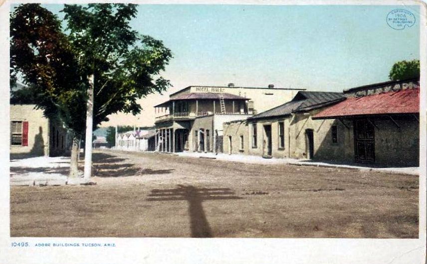
Tucson was always a city of three plazas. The cramped confines of the presidio nevertheless allowed a Plaza Militar and Plaza del las Armas for military drills, while San Agustín chapel faced La Plaza de Iglesia. After the village expanded and the walls began coming down, La Plaza Militar and La Plaza de las Armas were retained, while San Augustín Church faced La Plaza de la Mesilla. Anglos built the first protestant church and then a courthouse in La Plaza de las Armas and it soon became Court Square (now Presidio Park). La Plaza Militar became filled with homes but the US Army created another Military Plaza on the east side of town. La Plaza de la Mesilla, also known as Placita de San Augustine, survived as Church Plaza until the church was torn down in 1936 and the space became a parking lot, except for a small La Placita patch of grass that has survived.

This photo of Congress Street in 1887 by Campbell Studio, looking west toward the tree-lined acequia, shows a narrow but busy business artery with a group of O’odham women carrying their distinctive burden baskets. Anglo businessmen chose Congress and Stone as principle commercial streets and adopted a policy of widening Congress that encouraged demolition of adobes and replacement with brick buildings set further back. W. E. Rowland, watchmaker and jeweler is at lower left corner of the photo, followed westward by a barbershop, the US Bakery, and Palace Cigar Store advertised above the Congress Hall Saloon. The Saloon gave its name to the street, which had been called in Spanish Calle de la India Alegria (Happy Indian Street). This is the short block between Meyer and Church Plaza, with the intersection of Congress and Meyer in the middle of the scene. Pima County Sheriff Eugene Shaw resigned in 1887 due to ill health and died the same year. His brother was appointed to the office and then elected sheriff in 1888. Douglas Snyder, despite his banner across Congress, was apparently an unsuccessful candidate. (Arizona Historical Society photo 2911)

Meyer Street is pictured about 1905, lined by the type of Sonoran architecture that Anglos found unappealing. There are no setbacks between building facades and sidewalks and between sidewalks and narrow streets. Canales drain each flat dirt roof onto the sidewalk. There are cool, inner-court living spaces instead of showy front yards. Porches are out of sight, surrounding the inner court instead of facing the street. Design is defensive, instead of demonstrative. Anglos went to work to change the appearance of Tucson, at first adopting Victorian architectural styles popular in eastern states. Mission revival and California bungalow styles then became fashionable for a time. Tourism seemed to demand old west buildings by the 1920s, then mid-century modern styles were adopted to show how Tucson had progressed beyond its past. The Sonoran style has recently regained respect. This view of South Meyer Street appears to be looking north toward the intersection with Cushing Street (where the red roofs are). At that time Cushing did not extend across Meyer to meet Main Street. In addition, there was a slight bend to the east in Meyer one block north of Cushing. R. Rasmessen issued the postcard about 1907 or 1908. Many early Tucson scenes like this one were published by Rudolph Rasmessen (1875-1941) of Bauman & Rasmessen curio store on Congress Street.

This view of Hotel Hall at 33 W. Broadway was issued by Detroit Publishing Company in 1906. By then, 20 years of city water supply had allowed planting of trees and some adobe buildings had been fitted with pitched roofs and porches. Anna B. Hall purchased and renovated the building for Hotel Hall in 1894. Mrs. C. C. Hawley acquired the hotel some time before 1912. The view is to the west and Stone Avenue crosses in the foreground. Grace Episcopal Church (1893) is just out of view at left (you can see its shadow). The church moved in 1914 and the building was torn down in 1955. The white adobe building down the street with a purple “X” marking it is Sisters Convent and Academy, opened in 1870 by Sisters of St. Joseph of Carondelet, with the trees of Church Plaza beyond. The street ends at the Palace Hotel on Meyer, demolished in1923. The only building on this block to survive is the Charles O. Brown house, across the street from Hotel Hall and believed to have been built in the 1840s. Brown (1829-1908) was owner of the Congress Hall Saloon.

Despite a nation-wide recession, Tucson formed a village government and held its first municipal election in 1873. As the largest town in Arizona it was the supply center for all of southern and eastern Arizona, noted Richard J. Hinton in 1877, with eight or nine merchants pulling in $1.2 million in business on average each year. (Handbook to Arizona, p.271) In 1877, Tucson incorporated as a city. The first two banks opened in 1879. Banking had previously been offered by mercantile establishments. March 10, 1880, Southern Pacific Railroad tracks were built into Tucson from the west coast, continuing to El Paso the following year.

The coming of the railroad changed Tucson dramatically. Shipping costs fell, travelers came in large numbers and Anglos increased their control over government and the economy. They wanted the Old Pueblo to appear a modern city of prosperity and rule of law. “The future building material for Tucson will be brick and stone. The adobe must go, likewise the mud roof. They belong in the past and with the past they must remain.” (Arizona Daily Star, 20 Aug. 1892, quoted in p. 2, Archaeology In Tucson newsletter of Center for Desert Archaeology, Summer, 1996) Land sales boomed, part of the motivation for changing the appearance of the town, but then collapsed. Still, the makeover of the “ancient and honorable pueblo” would continue for another hundred years.

Under Spanish domination, Tucson had developed along the royal road, El Camino Real, running north and south through the Santa Cruz valley. It was really the only regular “street” in town until after 1866. Even when Anglo businessmen first came, their commercial buildings were along this road, renamed Main Street. After the railroad arrived Anglo businessmen developed Congress, and Stone, probably the widest street in town, and set about widening west Congress. It’s surprising to consider how much Tucson changed during a slow economy, even as the population dropped by almost one-third between 1880 and 1890.

Tucson Bishop Salpointe established St. Mary’s Hospital, dedicated 24 April 1880, and asked the Sisters of St. Joseph to staff it. Two years later he sold the hospital to the sisters for $20,000. The seven Sisters of St. Joseph of Carondelet, members of a society extended from France to Carondelet, Missouri in 1836, journeyed from St. Louis to San Francisco to San Diego and then across the deserts in a wagon to a grand welcome in Tucson May 26, 1870. A two-story convent and chapel building (at left) was added to the hospital (in center) in 1893. The circular tuberculosis Sanitorium (right) was added in 1900. This view of the grounds probably dates to 1908, after electricity and a central heating plant had been installed. The location is on the west side of the river, with Tumamoc Hill behind at left. For decades the Southern Pacific Railroad contracted with St. Mary’s until it built its own hospital in 1930. The sisters added St. Joseph’s Hospital on the east side of town in 1961 and the round Sanitorium shown here was demolished in 1965.

The Sisters of St. Joseph cared for orphans at their old convent across the street from St. Mary’s Hospital. Then, their La Comisaria School, a parochial school for girls housed in a former military commissary, became an orphan asylum, probably in 1905 when St. Joseph’s Orphans Home was established. The California mission style building shown on this postcard was likely constructed in 1922. It was demolished January 31, 1958. In addition to the first girl’s school next to San Agustín Church (in the Hotel Hall picture above), the sisters also established an Indian school at San Xavier in 1873 and a secondary school, St. Joseph’s Academy, in 1885.

Tucson merchant Albert Steinfeld (1854-1935) purchased this building on the corner of Main and Franklin for use as his home in 1908 (the same year this postcard was mailed). The Henry Trost (1860-1933) design had been built in 1899 for the Owls Club, where Steinfeld was a member. The building is still there. The California mission style surpassed Victorian designs in popularity during the opening decades of the twentieth century, especially for public buildings, and many fine examples have survived across Tucson.

By 1902, the appearance of Tucson had been transformed by renaming and realigning streets and adding a European business district and Victorian style neighborhoods surrounding the old Mexican pueblo on the north and east. Connell’s 1901 city directory explained the contrast. “Many of the streets are narrow and tortuous, being walled in by square adobe houses, while others are wide and beautiful, and bordered on both sides by costly dwellings.
“For many years Tucson was a dull, dead Mexican town, but today it is growing and advancing with wonderful strides.”

Congress Street is shown here about 1905, looking east toward the intersection with Stone Avenue. On the southeast corner of the intersection is Consolidated National Bank (1900) with Corinthian columns framing the corner entrance. The building on the other side of the street, in the middle of the block, with a Moorish onion dome on top, is J. Ivancovich & Co, grocery. John Ivancovich (1865-1944) ran the business until 1929. The building on the right with the “Photo Studio” sign is the Jacobs Block.  The photo studio was owned by Henry Buehman (1851-1912). The red brick building at far right houses George Martin Drug Store.

This detail from a postcard based on a 1906 photo shows the center of the Anglo business district, looking southeast, viewed from the Court House (1883) cupola. The street shown above is in the middle of this birds-eye-view. Windsor Hotel & bar (bottom right corner) is on the northwest corner of Congress & Church Streets. On the southeast corner is the red brick Martin Drug Store, with the blue, sloped roof of Grace Episcopal Church on Stone Avenue and the blue flat roof of Hotel Hall just visible behind. In the distance at top left is the white Santa Rita Hotel (1904), followed left to right by red Safford School (1884) and Carnegie Library (1901), with St. Joseph’s Academy (1886) in upper right corner. Martin Drug is now the site of Norwest Tower (1986), renamed in 2000 UniSource Energy Tower. Safford School is still there, but in a mission style building built in 1918. St. Joseph’s Academy building, a former Catholic secondary school, was purchased in 2004 by an investment firm and remodeled to become Academy Lofts apartments (460 S. 6th Ave.).

Forced to reoccupy Tucson after abandoning it, Union troops set up camp in the desert just southeast of downtown 20 May 1862, calling the place Camp Tucson. They went into town on Camp Street, later renamed Broadway. The camp was abandoned 15 September 1864 and then reoccupied as Camp Lowell 29 August 1866. The occupied area expanded to 367 acres. When Camp Lowell moved seven miles northeast of town on Rillito Creek 31 March 1873, the old campsite was abandoned but came to be called Military Plaza. In December 1899 city government seized the area to sell it to developers. The City won a long court battle with businessmen led by druggist George Martin, Sr. (1832-1907) and grocer Gustav A. Hoff (1852-1930) who wanted the Plaza to remain public, a city park. But only two of the six blocks, as shown in this postcard from about 1910, were retained by the City. When Carnegie Library (red dome behind flagpole) was completed in 1901 the Plaza was renamed Washington Park, then Armory Park after a National Guard Armory was built there in 1914 (located on the grassy area at lower right). This view is from the top of old Safford School, looking northwest. In the distance behind the library (left to right) can be seen St. Augustine Cathedral (1896), the white Old Pueblo Club (1907), the Court House cupola and the white Santa Rita Hotel. A 1941 fire destroyed the library rotunda in back but the rest of the building survived and is now the Tucson Children’s Museum. The brown building with black roof on the north side of the square (at right) is the Willard Hotel, a 1902-1904 remodel of the Casey Hotel. After serving as the Pueblo Hotel 1944-1984 and then sitting vacant for many years it was restored 1991-1993 and now houses law offices. The armory was demolished in 1960, replaced by the present Armory Park Center.

See:

G. W. Barter, Directory of the City of Tucson. . ., (1881)
Charles T. Connell, City of Tucson General and Business Directory 1901
Bernice Cosulich, Tucson, (1953)
Jane Eppinga, Tucson, (2000)
Rochester Ford, Tucson, Arizona, [1902]
A. M. Gustafson, John Spring’s Arizona, (1966)
Allan B. Jaynes, Tucson, Arizona’s Metropolis, [1906]
Alex Jay Kimmelman, “Strictly White and Always Sober. Tucson’s Pioneer Hotels: A Photo Essay.” Journal of Arizona History, Spring 1994, pp. 63-80
T. R. Sorin, Handbook of Tucson and Surroundings, (1880)
Southwestern Mission Research Center, Tucson. A Short History., (1986)
Ike Speelman, Historic Photos of Tucson, (2007)
University of Arizona, Barrio Historico Tucson, [1972]
Anne I Woosley & Arizona Historical Society, Early Tucson, (2008)